Reconnaissance of Southern Guam
AS THE OPERATIONS OF THE ASSAULT PHASE neared a close, the III Amphibious Corps started preparations for the next phase. By the morning of 28 July the capture of the main objectives on Guam-Orote airfield, Apra Harbor, and the high ground commanding them-seemed certain to take place within a day or two. However, there were convincing indications that the Japanese had not used up their means of resistance in the defense of this area. The corps had taken only 30 prisoners and killed 4,000 Japanese, about one-fifth of the estimated enemy strength on the island. Furthermore, the corps casualties, about 5,000, were half as many as the troops on Saipan had suffered in taking similar objectives, the Aslito air strip and its commanding heights. Evidently the Japanese were holding a considerable part of their strength in reserve for a stand in some other part of the island. The question before General Geiger was where this stand would be.
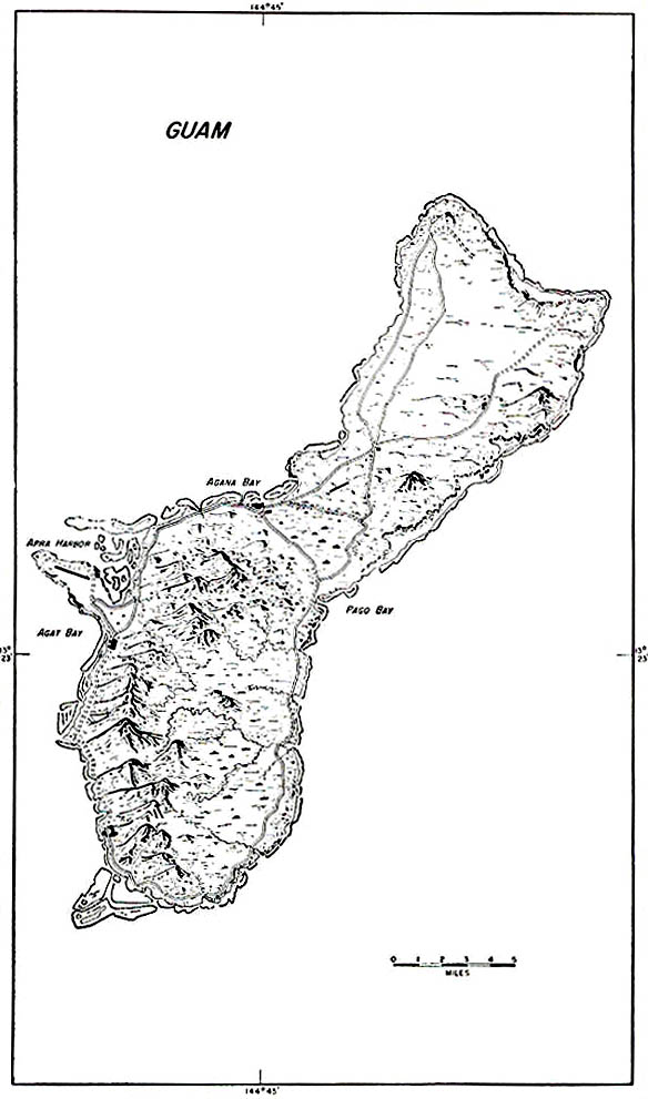
He expected that the Japanese would group the bulk of their forces in northern Guam, where they could use heavy equipment. Any defense of the southern part of the island would necessarily be by small elements of infantry with light weapons; there were few roads to the inland regions and none of them were passable for motor traffic during the extremely rainy months of July and August (Map No. 4, page 12). In contrast, a good road network throughout the whole northern area would provide freedom of movement for large enemy units and their supplies. In addition the thick jungle and scrub growth on the limestone plateau would conceal their installations and their marches. Strongpoints on Mts. Barrigada, Santa Rosa, and Mataguac would command this part of the island. Because of these advantages of defense the enemy was believed to have set up supply dumps, fortifications, and emergency headquarters in northern Guam.
57
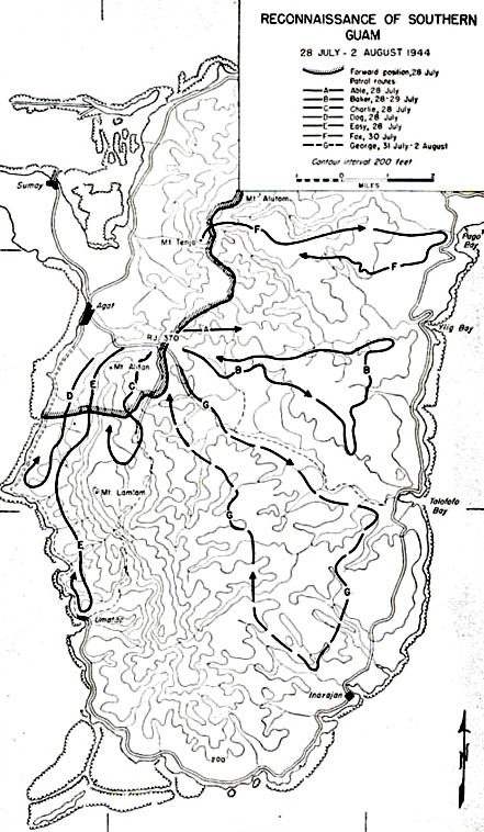
MAP NO. 12 Reconnaissance of Southern Guam, 28 July-2 August 1944
58
59
Captured documents indicated that the 10th Independent Mixed Regiment, which according to previous intelligence reports was the only unit occupying southern Guam, had moved north from the vicinity of Inarajan to the Agana area. However, elements of the regiment might have remained in the south, or other units had perhaps gone down there. Reconnaissance pilots and lookout guards, watching for enemy movements, had not been able to determine how many troops were still in the south. Far more definite information on enemy strength to the east and south of the 77th Division's beachhead was needed before an advance from the final beachline could be started. Even scattered enemy groups, in position to attack the III Corps right flank, might seriously endanger a maneuver to the east and north.
The mission of getting more intelligence about enemy Strength in southern Guam fell to the 77th Reconnaissance Troop, which would move out on foot and search the ridge south of Mt. Alifan to Umatac, and the eastern coastal area between Ylig Bay and Talofofo Bay (Map No. 12, page 58). Five patrols of about five men each, with native guides, would penetrate six miles each way south and east of Alifan into unknown territory. Patrols Able and Baker would proceed east from Road Junction 370 to the coast and return. Patrols Charlie, Dog, and Easy would move directly south along the ridge. Routes were laid out by division command, but the patrols were instructed that they could vary these if it seemed desirable. They were to report in by radio every two or three hours if possible and could call for artillery support if they needed it.
The assignment was a dangerous one, particularly so for green troops. All indications were that the Japanese did not hold the southern island in force, but they might have left behind strong parties for missions of harrying the beachhead. The five-man patrols of the 77th would have to match their wits with an enemy who was noted for his ability in hide-and-seek warfare and who knew every inch of the island. The patrols would lack the usual advantage of U.S. troopsenormous fire powerand would be at the mercy of any large enemy group. But they would benefit by a psychological advantage which General Bruce had prepared by sending beachline patrols on increasingly long trips during the previous week. These had made little contact with the Japanese, and their reports were reassuring.
60
Early on the morning of 28 July the patrols moved out toward their objectives,
Able and Baker covering the eastern shore and Charlie, Dog, and Easy reconnoitering
the ridge south of Alifan. Able, assigned Ylig Bay, got less than halfway
to the bay when the native guide and two members of the patrol were overcome
by fever and had to stop. Shortly after 1200 the patrol turned back, reaching
the divisional lines later that afternoon. The return of Patrol Able left
Baker responsible for the whole area from Ylig to Talofofo Bay. Commanded
by 2d Lt. Jack B. Miller and guided by Tony Cruz the four men in Baker
Patrol headed for the high ground overlooking Talofofo Bay. Less than a
mile from Road junction 370 they saw five Japanese in open ground to their
front, but both groups went to cover and bypassed each other without incident.
The scouts continued toward the bay and spent the night in a cave near
there. Next morning Patrol Baker received orders from
[61]
MAP NO. 13 Pursuit Phase, III Amphibious Corps, 31 July-1 August 1944
division headquarters to go to Ylig Bay, taking over Able's mission. Approaching Ylig the scouts met a small group of Chamorros, who greeted them joyfully and reported that many Japanese troops were to the north but that only small groups of 10 or 15 were still in the southern area. On the return trip to the road junction the men found tracks and other signs confirming the natives' report of Japanese movement to the north.
At the same time Patrols Charlie, Dog, and Easy proceeded along both sides of the range south of Mt. Alifan. On the slopes of Mt. Lamlam the scouts of Charlie and Dog were held up by sniper fire and decided to go back to the division lines. Patrol Easy reached Umatac and swung around to take the beach road north. The Easy
62
scouts reported that they had seen little enemy activity and that the natives were friendly.
The information gathered by the 25 scouts of the 77th Reconnaissance Troop verified General Geiger's expectations that the enemy had organized his main defenses north of the Agana-Pago Bay line. He could now go ahead with plans for the second phase, arranging for only a small security detachment from the 77th Division to protect the right flank of the corps when it crossed to the waist of the island, and to deal with the Japanese in southern Guam when the corps moved to the north.
Pursuit to the North
W+9 found the III Amphibious Corps ready for further conquest. Controlling a 25-square-mile beachhead which the corps had developed since W Day, the 3d Marine Division and the 77th Division awaited instructions from General Geiger to pursue the enemy to the northern part of the island, where the enemy had an area about 15 miles long and 5 to 8 miles wide in which to choose his ground for maneuver and last-ditch defense. Back on the beaches, corps supplies had been accumulating for this large-scale advance.
The pursuit phase, as defined in General Geiger's order of 30 July, was to swing the corps across the waist of the island, cutting off the northern area (Map No. 13, page 62). The first objective, the O-1 line, started east of Agana, followed the Agana-Pago Bay road to Famja, and then curved to the southeast along the high ground south of the Pago River. The O-2 line, farther to the north, ran through Road Junction 218 to the east coast about a mile west of Fadian Point. From the jump-off positions, those held by the corps along the final beachline, the maneuver would involve a wheeling movement to the northeast. As pivot, the 3d Division on the north would advance two to five miles from the line of departure, while the 77th Division on the circumference of the wheel swung nearly ten miles from the Tenjo-Alifan ridge. As a secondary assignment, the 77th Division would protect the corps' right flank and patrol to the south until relieved by the 1st Provisional Marine Brigade on the final beachline. The brigade was to conduct distant patrolling to the south from the beachline. The time for the jump-off was set at 0630, 31 July.
63
All three regiments of the 77th Division would participate in the pursuit. The 307th was to lead the advance, followed in turn by the 305th and the 306th. Both the 305th and the 306th Regiments would wait on the beachhead until the 1st Provisional Marine Brigade took over from them the protection of the corps' right flank. Within the 77th's zone of action the initial objective on the O-1 line was the high ground south of the Pago River. The 77th Reconnaissance Troop was to send out an advance guard to Pago Bay and continue patrolling to the south.
Operations of this phase for the 77th Division, working for the first
time on Guam as an integrated unit, presented major problems of transportation
and movement. From the Tenjo-Alifan ridge to
64
Pago River, a distance of about six miles, no roads existed. The trails, unsurfaced and narrow, were not suitable for the heavy traffic that a supply route would demand, and even for the infantrymen they were inadequate. Much of the march had to be cross-country, down the steep slopes and through the foothills of the range toward the eastern coast.
The 1st and 3d Battalions of the 307th with the 3d Battalion of the 305th (temporarily under 307th control) moved out on schedule from the vicinity of Mt. Tenjo. The 1st and 3d Battalions of the 307th were the leading elements in the 307th's sector, on the left; the 2d Battalion was initially in reserve. The 3d Battalion of the 305th was on the right of the 307th. Battalions marched in a column of companies, most of the time with platoons abreast. Because of the lack of a road across the island, the infantry carried heavier loads than usual. Men of the heavy-weapons companies labored under their burdens of machine guns, mortars, and ammunition. jeeps were able to follow part way, but soon the terrain became too rough. As one man wrote later:
65
command to direct that they reach the O-1 line south of the Pago River that night. An artillery observation plane dropped General Bruce's order to this effect.
Following these instructions, the 1st and 3d Battalions of the 307th and the 3d Battalion of the 305th pushed ahead. As the men of Company I, 305th, commanded by Capt. Lee P. Cothran, moved rapidly along the dirt road entering Yona from the southwest, they discovered that Patrol Fox had overlooked some enemy troops in that village. The first two Japanese running across the trail in front of the 2d Platoon put Company I on guard. When the platoon opened fire, the Japanese disappeared in dense brush on the side of the road. Company I's men moved forward under
66
small-arms fire, and more Japanese were sighted running hastily among the grass huts in the town.
Facing continued scattered fire from huts and pillboxes now visible to the 2d Platoon, the squads formed a skirmish line to sweep through the enemy positions. As the 2d Platoon moved along on a 150-yard front, the squads lost contact with one another, but they went about their work systematically, grenading the buildings and shooting down their occupants with rifles and BAR's.
The Japanese were evidently taken by surprise. Some of them ran out of the buildings naked or half-dressed and made off for the brush. Others fired occasionally from dugouts and buildings but then waited to be killed.
67
Other elements of Company I were rapidly coming up in support. The 1st Platoon moved out toward the highway on the right to protect the flank and rear of the 2d Platoon in the village. The 3d Platoon went to the left (north) of the 2d. Although communication with the battalion command post was out, reinforcements arrived as regularly as in any practice exercise. Company K moved in behind Company I, and with this support Company I pushed rapidly through the village. The weapons platoon set up its light machine guns and the heavy machine guns from the attached elements of Company M on the forward slope of a small knoll running into the town. The machine guns fired into the flimsy huts, from which the Japanese could put up only slight resistance. As the last buildings were neared, the enemy survivors fled into the jungle beyond the village. They left behind a considerable supply of hand grenades, small arms, and ammunition. One of the buildings, obviously used as a Japanese barracks, was littered with dirt and trash and looked as though it had never been cleaned. The natives stated that Yona had been a supply center and garrison for several hundred soldiers, and that they had been forced to work for the Japanese.
The skirmish at Yona made the men of the 3d Battalion, 305th, uneasy about the night, for they were getting close to areas which might be well defended. They arrived near the south bank of the Pago River after dark and set up their perimeter on a hill overlooking the bay. Their uneasiness increased as the hour grew later because they had little time to dig fox holes in the hard coral, and their perimeter was separated from the 307th to the left by a large gap. During the night they once heard Japanese marching on the road below and held their fire in order not to attract the attention of any large group of enemy that might be near. However, the night passed without any further alarms.
An outstanding event of the day for the "Statue of Liberty" Division was the liberation of 2,000 Chamorros who were huddled in a concentration camp near Asinan. Patrols of Company L, 307th, found the camp unguarded. They let the natives out and directed them back toward their homes on the west side of the island. The (ex-captives were almost beside themselves with joy. Not knowing whether to kiss their liberators, bow to them, or shake hands with them, they tried to do all three at once. Many carried tiny American flags which they had hidden from the Japanese. "We wait long time
68
for you to come," some of them said. Their faith in the return of the Americans had apparently never faltered, although as one Chamorro scornfully said, "We were told by the Japanese that the U. S. A. was being defeated, that Japan had control of the Hawaiian Islands, and that the Americans had only one ship left as the rest had been sunk."
The weary infantrymen were immensely moved by the joy of the natives as they passed back through the lines. Soldiers who had been complaining because their rations were low gave away what -few cigarettes they had. While watching the tiny children who carried huge baskets, and the women who trudged along with half their household possessions on their backs,1 the soldiers realized the meaning of liberation for these enslaved people.
1. The natives passed under the jurisdiction of III Amphibious Corps when they reached their homes and farms. The Insular Patrol Force, a former volunteer native military organization, was reestablished as the Local Security Patrol Force on 8 August. Those who returned to Agana found their homes largely destroyed by the pre-invasion bombardment, and the inhabitants of Agat found no town left at all. But they set about rebuilding their towns, and during the operation many of them helped maintain roads to keep supplies moving forward to the front lines.
69
Apart from the resistance at Yona, the 77th Division had met only small groups of Japanese on its march to the O-1 line. The Pago River was the first natural barrier where the Japanese might attempt strong defense, but patrols crossing the river had found no installations along it. From additional information at his disposal, General Bruce believed that the enemy must be preparing his stand farther north. Interrogations of natives revealed that 800 Japanese had moved from the Yona area toward Barrigada. The 3d Division, on its front, also continued to hold this view, despite an undated pigeon message which the division had captured indicating that the enemy planned a withdrawal only to the Agana-Pago Bay road. "Because of unusual conditions," the message read, "move to Sinajana or Ordot. Fire being received in depression to our front making movement difficult. . . . Hold on."
70
The 3d Division had gone beyond both of these towns before noon without meeting resistance, and information received from natives and divisional patrols pointed out that the enemy must be preparing defenses at Tiyan airfield or Tumon Bay. This field intelligence confirmed General Geiger's belief that for both the 3d and 77th Divisions 1 August would be another day of pursuit. The enemy seemed to be north of the O-2 line. A principal gain in the second day of pursuit for the marine and army divisions would be to secure the entire length of the Agana-Pago Bay road, which could be used as a main supply route from the beachheads to the forward positions of both divisions.
The 77th Division pressed forward early in the morning of 1 August. The 3d Battalion, 305th, now under the control of its own regiment, continued on the right, the 1st and 3d Battalions of the
71
MAP NO. 14 Construction of New Road, 302d Engineer Combat Battalion, to 31 July 1944
72
307th on the left in contact with the 3d Marine Division. Necessary for a rapid advance was the bridge over the Pago River on the Agana road. Company K moved out first to make sure that it was intact and not defended. The 1st and 3d Battalions, 307th and the 3d Battalion, 305th followed Company K. Their route of march was cross-country through jungle and over rough terrain to the O-2 line. On the way the troops found an enemy dump containing knee mortars, light machine guns, rifles, and bayonets, but they saw no Japanese. They also found some canned salmon and strawberry gum drops which the troops devoured because the supplies which they carried with them were running out. Their canteens were empty, so they drank coconut juice instead of water; some of them had what tasted like a "warm Tom Collins" which they made from a pint of saki, three packages of synthetic lemon powder, and two lumps of sugar. These "extras" kept the men going until their supplies of rations arrived. They reached the O-2 line by evening.
Behind them other elements of the division moved up, the foot troops following the trails across the island while the units with heavy weapons, such as artillery and tanks, took the coastal highway from Agat through Agana and into the waist of the island toward the 77th's sector. This route between Agana and Pago Bay was now entirely under corps control, for the 3d Marine Division had swung up to the G-2 line in its sector by early in the evening.
77th Division's Supply Route
In the 77th Division's zone the pursuit phase involved a special challenge to the engineers. It was impossible to move supplies directly across the island from Agat to Yona without first building a road which would extend from the Harmon Road leading out of Agat to the coastal surfaced highway near Yona (Map No. 14, page 72). The division had proposed the building of such a route, involving construction for ten miles, and Companies A and C of the 302d Engineer Combat Battalion had begun work on it soon after landing. By 31 July when the 77th Division moved out toward the waist of the island, the engineers had finished the road to south of Mt. Tenjo. However, this 2- to 3-mile stretch had required work on a 24-hour schedule for 5 days.
73
On 31 July the 302d Engineers started into very rough country where their task increased in difficulty, though the problems already encountered were discouraging enough for rapid completion of the route. When bulldozers (D-6's) leveled a two-lane width, the seemingly bottomless clay offered no firm foundation. Heavy rains made the clay a quagmire, and coral or other rubble had to be hauled in great quantities to give the top soil a harder surface. Furthermore, the engineers did not have equipment to construct good drainage systems. Initially they improvised culverts out of coconut logs, but later they used oil drums with the ends cut out and welded together in three or four lengths. Preparing either the coconut logs or the oil drums was a process which slowed the work. The prospects of finishing a satisfactory route within a short time was doubtful when all these problems combined with those presented by rough terrain near Mt. Tenjo. Even the short stretch of road which bad been completed required day and night maintenance. On the 31st, the 77th's construction work was stopped and the route was abandoned.
Fortunately the corps' advance to the O-2 line would provide a solution for the 77th Division's supply problem. The division had proposed that it be allowed to reroute its supplies over the coastal highway in the 3d Marine sector, and General Geiger approved a plan on 31 July for the 77th Division to use this highway as soon as it was in corps possession all the way from Agat through Agana to Pago Bay. The continued pursuit on 1 August made the road available to the 77th. Although it was already overburdened by traffic serving the marines and corps artillery, absence of attacks-by enemy artillery or planes made its use by the army possible. All available trucks, with their lights on after dark, began grinding over the road and kept food and ammunition moving forward to two combat divisions. Of the use of a single supply road by two divisions General Bruce said later, "The book would say it can't be done, but on Guam it was done it had to be." Before noon on 1 August the men of the 77th Division, who had been living on a restricted diet, were delivered a new supply of rations for their breakfast.
74
page created 28 June 2001