Introduction
THE 5307th COMPOSITE UNIT (Provisional) of the Army of the United States was organized and trained for long-range penetration behind enemy lines in Japanese-held Burma. Commanded by Brig. Gen. (now Maj. Gen.) Frank D. Merrill, its 2,997 officers and men became popularly known as "Merrill's Marauders." From February to May, 1944 the operations of the Marauders were closely coordinated with those of the Chinese 22d and 38th Divisions in a drive to recover northern Burma and clear the way for the construction of the Ledo Road, which was to link the Indian railhead at Ledo with the old Burma Road to China. The Marauders were foot soldiers who marched and fought through jungles and over mountains from the Hukawng Valley in northwestern Burma to Myitkyina on the Irrawaddy River. In 5 major and 30 minor engagements they met and defeated the veteran soldiers of the Japanese 18th Division. Operating in the rear of the main forces of the Japanese, they prepared the way for the southward advance of the Chinese by disorganizing supply lines and communications. The climax of the Marauders' operations was the capture of the Myitkyina airfield, the only all-weather strip in northern Burma. This was the final victory of the 5307th Composite Unit, which was disbanded in August, 1944.
The War in Burma, January, 1942 - March, 1943
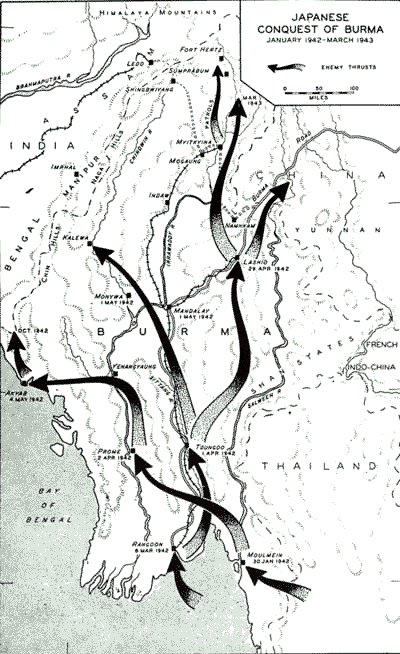
Burma had been conquered by the Japanese 2 years before the Marauders' operations (Map No. 1, opposite). During the 6 months
1
2
between December, 1941 and May, 1942 the enemy had overrun the, Philippines, much of Oceania, all of the Netherlands East Indies, all of the Malay Peninsula, and almost all of Burma. In the Pacific Ocean his advance threatened communications between the United States and Australasia. On the Asiatic mainland his occupation of Burma menaced India, provided a bulwark against counterattack from the west, cut the last land route for supply of China, and added Burma's raw materials to the resources of an empire already rich.
For the conquest of Burma the Japanese had concentrated two divisions in southern Thailand (Map No. 2, page 4). In mid-January, 1942 they struck toward Moulmein, which fell on the 30th. British, Indian, and Burmese forces, aided by the Royal Air Force and the American Volunteer Group, resisted the Salween and Sittang river crossings but were overwhelmed by enemy superiority in numbers, equipment, and planes. Rangoon, the capital and principal port, was taken on 8 March. The Japanese then turned north in two columns. One division pushed up the Sittang where Chinese forces under Maj. Gen. (now General) Joseph W. Stilwell were coming in to defend the Burma Road.1 The other Japanese division pursued the Indian and Burmese forces up the Irrawaddy Valley. On 1 and 2 April, the enemy took Toungoo on the Sittang and Prome on the Irrawaddy. From Yenangyaung, north of Prome, a column pushed westward and on 4 May took the port of Akyab on the Bay. of Bengal. The conquest of southern Burma was complete.
A third enemy column of two divisions, which had landed at Rangoon on 12 April 1942, was now attacking on the east from the Shan States into the upper Salween Valley and driving rapidly northward to take Lashio, junction of the rail and highway sections of the Burma Road. Mandalay, completely outflanked, was evacuated by its Chinese defenders and occupied by the Japanese on 1 May. From Lashio the Japanese pushed up the Salween Valley well into the Chinese province of Yunnan. In north central Burma they sent a small patrol northward along the Irrawaddy almost to Fort Hertz, and to the west they took Kalewa on the Chindwin. The main rem-
3
4
nants of General Stilwell's forces retired from north Burma to India by way of Shingbwiyang, while British, Burmese, and Indian survivors withdrew up the valley of the Chindwin and across the Chin Hills. The Allied withdrawal was made on foot, for no motor road or railway connected India with Burma.
When the monsoon rains came in June the Japanese held all of Burma except for fringes of mountain, jungle, and swamp on the north and west. General Stilwell grimly summarized the campaign: "I claim we got a hell-of-a-beating. We got run out of Burma, and it is as humiliating as hell. I think we ought to find out what caused it, go back, and retake it." But this counteroffensive could not start at once, and the Japanese were able to make further advances in the next fighting season.
At the end of October they pushed northwestward along the coast from Akyab toward Bengal. Approximately a month later British forces counterattacked strongly along this same coast, but their gains could not be held, and the Japanese force reached the frontier of Bengal. In February of the next year the enemy began to drive northward from Myitkyina. He had covered some 75 air miles by early March and was closing in on Sumprabum, threatening to occupy the whole of northern Burma and to destroy the British-led Kachin and Gurkha levies which had hitherto dominated the area. The Allies were in no position to stop this advance. Their regular forces had retired from the area to India in May and were separated from the Japanese by densely forested mountain ranges and malarial valleys.
The enemy was apparently secure in Southeast Asia. The question of the moment was whether his advance would halt at the Burma border or would continue into India.
From Defense to Offense
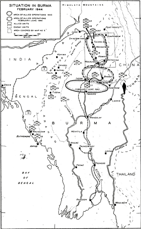
The strategic situation in Burma began to change in the spring of 1943 when the Allies assumed the offensive with an experimental operation behind the enemy lines (Map No. 3, page 6). This operation, foreshadowing the part the Marauders were to take in the larger offensive of 1944, was an expedition commanded by Maj. Gen. (then Brigadier) Orde C. Wingate, who led long-range-penetration units of the 77 Indian Infantry Brigade across the natural barrier between India and Burma into Japanese-held territory.
5
6
Wingate's forces consisted of eight jungle columns totaling 3,200 men, assembled from British, Indian, Burmese, and Gurkha troops. Directed, by radio and supplied by air drops, in a period of 4 months (February to June, 1943). his columns covered a distance of 1,000 miles. In the area of northern Burma, from the Chindwin River eastward to China, they gathered topographical and other intelligence, harassed and confused the Japanese forces, and cut enemy lines of communication. The columns put the Mandalay-Myitkyina railway out of action for 4 weeks and engrossed the efforts of six to eight enemy battalions. When ordered to return, the columns dispersed in small groups, each of which successfully fought its own way out of Burma.
After this first penetration the seasonal rains again restricted ground activity. However, Allied bombers of the Tenth Air Force continued their attacks on Japanese supply lines in both Burma and Thailand with steadily increasing strength. Maj. Gen. George E. Stratemeyer's force had established definite superiority over Burma by November, 1943, the beginning of the dry season during which a ground offensive was possible.
At this time many indications pointed to a resumption of the Japanese offensive against India. Since the fall of 1942 the enemy had brought two more divisions into the area, making a total of five distributed along the India border. The one division (55th) on the front beyond Akyab was extremely aggressive. In the Chin Hills three others (the 15th, 31st, and 33d) were organizing for a strong offensive into Manipur Province. The 18th Division, in northern Burma, was ready to oppose any advance from Assam.
The Allies, too, were preparing for major offensive operations from both India and China. Admiral Lord Louis Mountbatten,2 commander in Southeast Asia, was assembling troops and supplies in Bengal and Manipur. Generalissimo Chiang Kai-shek was strengthening his forces along the Salween River in Yunnan. The first Allied blow was to come from the north, led by General Stilwell, Deputy Commander in the Southeast Asia Command and Chief of Staff for Allied operations in the Chinese theater. Operating from bases in the upper Brahmaputra Valley, General Stilwell had mounted an offensive to carry over the Patkai Range, conquer northern Burma,
7
and open a new land route to China. American-trained Chinese divisions constituted his main striking force. In immediate support of his advance, long-range-penetration operations were to be carried out by combat teams of the 5307th Composite Unit (Provisional) under General Merrill.
By February, when the 5307th arrived in the area of operations, General Stilwell's offensive had made good progress. The Chinese 22d and 38th Divisions had crossed the Patkai barrier and were engaging the Japanese forces in the flood plains of the Hukawng Valley. Covered by this advance, United States engineers had pushed a road over the Patkais to Shingbwiyang, 100 miles from the starting base at Ledo. However, the main enemy resistance and strongest prepared positions were still to be met.
Secondary Allied operations had been planned to support the main drive into north Burma. General Wingate's jungle columns of the 3 Indian Division were ready to thrust into central Burma, with the aim of cutting enemy communications far south of General Stilwell's objectives. On the Irrawaddy headwaters in northeast Burma the Allies had a base at Fort Hertz, in wild country which the Japanese had never been able to conquer. Here, Gurkha and Kachin levies from the native tribes were harassing Japanese outposts in the Sumprabum-Myitkyina corridor.
Origin and Training of the American Force
The 5307th Composite Unit (Provisional) was organized to participate in the Burma operations as the result of a decision made at the Quebec Conference in August, 1943. Five months later, on I February 1944, the three battalions comprising the provisional unit had been transported to India, organized, trained, and equipped for employment. They were the only American ground combat troops designated at this time for the China-Burma-India Theater.
On 1 September 1943, when the size of the battalions had been fixed at 1,000, the War Department began recruiting personnel from jungle-trained and jungle-tested troops, primarily infantrymen. General George C. Marshall requested 300 volunteers "of a high state of physical ruggedness and stamina" from the Southwest Pacific, 700 from the South Pacific, and 1,000 each from the Caribbean Defense Command and the Army Ground Forces in the United States.
8
COL. CHARLES N. HUNTER
Second in Command
5307th Composite Unit (Provisional)
9
In answer to General Marshall's request the South and Southwest Pacific commands selected 950 men from veterans of Guadalcanal, New Guinea, and other operations in those theaters. The Caribbean Defense Command secured 950 more troops who had served on Trinidad and Puerto Rico, and a similar number came from highly trained units within the United States. The Caribbean volunteers flew to Miami, crossed the continent by rail, and assembled in San Francisco with the volunteers from the States. These men formed two battalions; the third from the South and Southwest Pacific areas was to join the force on the way to Bombay.
Col. Charles N. Hunter, the senior officer among the volunteers, was appointed commander of the battalions. He was ordered to prepare the men while en route for the performance of their mission, to keep General Stilwell informed of the progress of the movement, and to report to the General upon arrival in the theater.
10
On 21 September, the two battalions sailed from San Francisco on the Lurline. As much of their equipment as could be loaded aboard went with them; the remainder was sent to San Diego, and from there it was to be forwarded in one shipment to Bombay.3 The Lurline proceeded to Noumea, New Caledonia, where 650 officers and men from the South Pacific Theater came aboard. The contingent from the Southwest Pacific joined the ship at Brisbane, Australia. After a brief stop at Perth, the Lurline steamed across the Indian Ocean and up the Arabian Sea to Bombay, where the three battalions disembarked by 31 October.
Organizing and training of the 5307th began immediately. Col. (now Brig. Gen.) Francis G. Brink, selected because he had trained Chinese troops in India, instructed the unit in long-range-penetration tactics. After meeting the Lurline at Bombay, he accompanied the troops to a British camp at Deolali and 3 weeks later moved with them to Deogarh, close to an area suitable for jungle training.
From the end of November, 1943 to the end of January, 1944 the 5307th remained at Deogarh and trained intensively. On the advice of General Wingate, who supervised the over-all preparation of the unit, each battalion was formed into two jungle columns, called "combat teams" by the Americans. These were not combat teams in the accepted American sense, for their organization represented only a division of each battalion into two smaller units, without any addition of elements not organic to the battalion. The division was made in such a manner that each "combat team" had its share of the heavy weapons and other organic battalion elements and thus was able to operate as a self-contained unit (Chart, page 14).
Lt. Col. William L. Osborne was assigned command of the 1st Battalion, and its two combat teams, Red and White, were placed under Maj. Edward M. Ghiz and Maj. Caifson Johnson, respectively (Chart, page 12). Lt. Col. George A. McGee, Jr., became commanding officer of the 2d Battalion, which was composed of Blue Combat Team under Maj. Richard W. Healy and Green Combat Team under Capt. Thomas E. Bogardus. The 3d Battalion was placed under command of Lt. Col. Charles E. Beach and comprised Orange Combat Team under Maj. Lawrence L. Lew and Khaki Combat Team under Maj. Edwin J. Briggs.
11
12-13
ORGANIZATION OF BATTALIONS
(This Table of Organization does not include supply base detachment at Dinjan.)
| Battalion Headquarters |
Combat teams | Total | ||
|---|---|---|---|---|
| No. 1 | No. 2 | |||
| Officers | 3 | 16 | 16 | 35 |
| Enlisted men | 13 | 456 | 459 | 928 |
Aggregate |
16 | 472 | 475 | 963 |
| Animals (horses and mules) | 3 | 68 | 68 | 139 |
| Carbines | 6 | 86 | 89 | 181 |
| Machine guns, Heavy | 3 | 4 | 7 | |
| Machine guns, Light | 2 | 4 | 6 | |
| Machine guns, Sub | 2 | 52 | 48 | 102 |
| Mortars, 60-mm | 4 | 6 | 10 | |
| Mortars, 81-mm | 4 | 3 | 7 | |
| Pistols | 2 | 2 | 4 | |
| Rifles, Browning Automatic | 27 | 27 | 54 | |
| Rifles, M-1 | 8 | 306 | 310 | 624 |
| Rockets | 3 | 3 | 6 | |
General Composition of each Combat Team: 6
Headquarters Platoon
Intelligence and Reconnaissance Platoon
Pioneer and Demolition Platoon
Medical Detachment
Heavy Weapons Platoon (3 heavy machine guns, 4 81-mm mortars)
1½ Rifle Companies
½ Company Headquarters
Colonel Brink, assisted by Lt. Col. Daniel E. Still, delegated supervision of training to the battalion commanders, who were encouraged to add their own ideas to the program. For slightly more than 2 months they prepared the men for the problems of operating in dense tropical jungles defended by a stubborn and skillful enemy.
Individual training emphasized marksmanship, scouting and patrolling, map reading, and jungle navigation. A normal amount of calisthenics was included in the daily routine, and the length and pace of marches were increased in order to make the men physically hard. Classes always marched to and from ranges and training areas, no matter how far they were from camp. Packs were worn whenever possible.
14
Platoon tactics were stressed in every training operation. Company, combat team, battalion, and unit exercises were also held, but time was short and attention had to be directed mostly toward moulding squads and platoons into highly efficient and well-coordinated teams. Each small unit was familiarized as much as possible with the normal combat activities of other types of units. Rifle platoon leaders and noncommissioned officers were instructed in directing mortar fire, and all men were taught the rudiments of voice radio procedure.
In general, the heavy weapons, intelligence and reconnaissance, pioneer and demolition, and communications personnel were already
15
well trained in their special functions. Taking part in all training of their combat teams, they became physically hardened to the same extent as the rest of the men. Rear echelon personnel, including parachute packers, riggers, and kick-out crews, were trained separately by the unit S-4.
Ten days spent on maneuvers with General Wingate's troops brought to light minor deficiencies. There was a shortage of pack animals, and the changes which had been made in organization and equipment required final adjustments.
After the commanders within the unit had been assigned, General Merrill was placed in charge of the entire force. He appointed Maj. Louis J. Williams as his executive officer, in charge of the Command Post group.
On 8 January 1944, the completely organized and trained unit was assigned to General Stilwell's field command in northern Burma.7 He expected to use it in conjunction with the Chinese forces which were beginning their drive against the Japanese 18th Division. In accordance with General Stilwell's concept of the use of long-range-penetration units, the 5307th was to be sent on bold missions against assigned objectives behind the enemy lines in order to facilitate the seizure of key points by the main Chinese forces.
General Stilwell's immediate orders to the 5307th were to close in on Ledo by 7 February and from there to march over the trail as far as Ningbyen. The unit started at once from the training area in order to arrive on schedule. The 1,000-mile trip by train and boat to Ledo consumed a month; the last 100 miles on foot took 10 days. On 19 February the 1st Battalion, head of the column, arrived at Ningbyen. It was followed 2 days later by the 3d Battalion, tail of the column. The men had been thoroughly tested by the 10-day march and were ready for their first assignment.
Area of Operations
Plans for the Ledo Road8 are the key to an understanding of the 1944 campaign in northern Burma (Map No. 4, page 17). Reopening land communications with China had become a main aim of Allied
16
17
strategy, but only the total reconquest of Burma would give the Allies control of the old route from Rangoon. The Ledo Road constituted a daring effort to drive a new route from northeast India across north Burma, tapping the Burma Road at the frontier of China. The base of departure, at Ledo in the Brahmaputra Valley, had rail and water connections with Bengal. Nearly 300 air miles separated Ledo from the projected point of link-up with the Burma Road near Bhamo.
The plans for the Ledo Road included the laying of pipe lines, designed to relieve the road and air traffic of carrying fuel from Assam to China. Once the construction of the road was settled, it was decided that two 4-inch lines from Tinsukia, 30 air miles northwest of Ledo, would follow the road. They were to be fed by gasoline pumped from Calcutta to a station near their starting point.
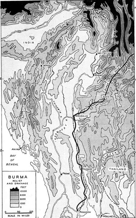
Military conquest of north Burma was a prerequisite for operations of the engineers, and for either infantry or engineers, the area presented major difficulties in terrain and climate. Abutting to the north on the impassable ranges of the Himalayas, where peaks rise to 20,000 feet, north Burma is separated both from India and China by massive frontier mountains. On the India side, a continuous range runs southwest from the Himalayas along the Assam border in parallel ridges reaching heights of 10,000 feet; in the Patkai portion of this range, southeast of Ledo, the Pangsau Pass at about 4,300 feet leads into Burma, making a gateway for the projected road. On the east, the Himalayas curve south along the China frontier to the region of Bhamo. Boxed in on three sides by these main barriers, north Burma is essentially a rugged hill country divided into two compartments by the north-south Kumon Range, with elevations over 10,000 feet. To the east of the Kumons, the Irrawaddy pushes a narrow valley north from Myitkyina into the Himalayas; Sumprabum was the main enemy outpost in this valley. In the other compartment, the headwaters of the Chindwin River have carved out fairly extensive lowlands in the hill country; one of these plains, the Hukawng Valley, lies near the Pangsau Pass over the Patkai Range. Reference to the physiographic map (Map No. 5, page 19) will show the geographic features that governed both the plans for the Ledo Road and the plans for the military operations that would clear the way for this new route to China. Once over the Patkal Range, the essential problem was to get from the Hukawng lowlands over into the upper Irrawaddy
18
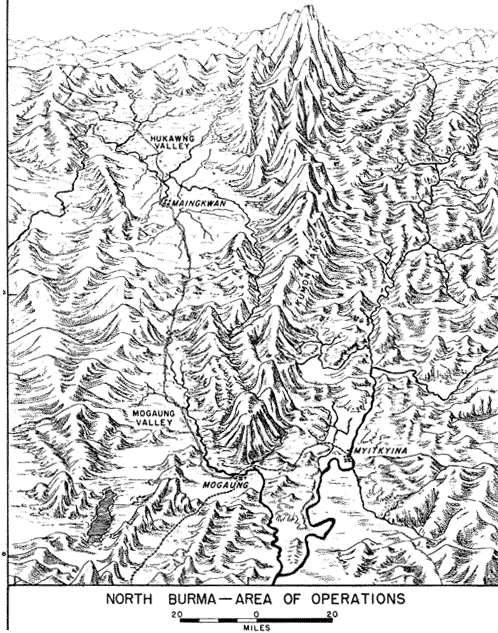
plains near Myitkyina. The best route was by a natural corridor, the narrow Mogaung Valley. This skirted the southwest side of the Kumon Mountains, then passed between them and the lower hills to the southwest to reach a tributary of the Irrawaddy River.
It was in this area of about 5,000 square miles, roughly the size of Connecticut, that the Marauders were to operate. When the three battalions of the 5307th arrived at Ningbyen, they had marched
19
through a typical portion of north Burma and had experienced the regional conditions under which they were to fight. They had struggled over the ridges of the Patkai Range, where, even in the relatively low country of the pass, they doubted whether "those goddam hills would ever level out." They had been impressed by the tropical rain forests characteristic of western mountain slopes in Burma, where trees 20 feet in diameter at the base rose straight and clean of branches to a dense roof of foliage at 80 or 100 feet. Brush was scant in the gloom of these forests, but the footing was poor in a mould of rotting vegetation 3 to 4 feet deep. In the Hukawng lowlands, the Marauders entered the typical jungle country of north Burma, and veterans of Guadalcanal soon learned that this jungle outmatched that of the Solomon Islands for difficulty. Trees were smaller and more scattered than in the mountains, permitting a rank growth of underbrush, often briary and tangled with vines. Patches of bamboo were sometimes so dense that to chop a trail involved cutting away the lower part of the growth to make a tunnel under the matted plant tops. Growth in the occasional clearings might consist of kunai ("elephant") grass, 4 to 6 feet high and sharp-edged. Everywhere in this country, whether on hills or in the river flood plains, men found that their clothes were damp all the time, even in the driest period of the year, and that their weapons rusted if not disassembled and oiled daily.
In a country of many large and small streams, heavy jungle, and rough hills, the problems of movement and transportation were made even more difficult by the absence of roads. North Burma is an undeveloped frontier country, and native footpaths and cart tracks provided the only means of communication in most of the area. The one road suitable for motor traffic, and then only in the dry months, ran north from Kamaing via the Mogaung corridor and into the Hukawng plain. The nearest railhead was at Myitkyina, reached by a single-track line connecting with central and southern Burma.
Burma has a tropical monsoon climate with clearly marked wet and dry seasons. From June to the end of September the moisture-laden southwest monsoon brings extremely heavy rains to the western and southern flanks of the highlands; annual precipitation on the westernmost hills varies from 150 to 250 inches. In northern Burma, slopes which face the monsoon also receive abundant rain, ranging
20
between 75 and 100 inches. In the months from January to April, many of the innumerable small streams dry up, and only the large rivers present difficulties for crossing. During the wet period, lowlands such as the Hukawng Valley and even the Mogaung corridor are flooded to the point where movement is greatly restricted; the Ledo Road was to provide the first all-weather route that northern Burma had seen. Temperatures are high throughout the year at lower altitudes but from October to February are not excessive, ranging from 60° to 90° in the lowlands, and during these months the weather is clear and pleasant. Though the dry season does not end until June, the weather becomes increasingly hot and humid from March until the monsoon rains finally break.
21
The heavily forested hills and valleys of north Burma are thinly populated by pagan Kachins, who have lived in almost complete independence of the government in Rangoon. In 1931 Myitkyina, the largest town, had only 7,328 people in comparison with Mandalay's 134,950 and Rangoon's 398,967. Localities named on maps in territory where the Marauders operated might turn out to be less than hamlets; Lagang Ga has fewer than five houses, and Inkangahtawng, only a jungle clearing, has not a single basha (hut). The settlements usually consist of from 12 to 100 or more huts, built of timber uprights and bamboo. To protect the inhabitants against wild animals the villages are often surrounded by bamboo and wooden stockades. Many of the primitive tribesmen living in this area first came into contact with people of the outside world when their country became a battleground for Allied and Japanese armies.
The vegetation in north Burma is limited almost entirely to large trees and dense underbrush. Wild nuts, fruit, or edible growths, usually found in quantities in jungle areas, are rare in the Hukawng and Mogaung valleys. In small clearings around the villages only enough rice is raised to provide food for the local inhabitants. Cultivated areas increase as southern Burma is approached, where the densely populated valleys and coastal plains show an intricate pattern of paddies producing the great staple crop of the country.
The Kachins are active as traders and mine the amber and jade found in the Hukawng Valley and around Myitkyina. They practice nature worship, in contrast to the Buddhism of the more civilized Burmans who occupy the lowlands to the south. When organized by Americans and British, the Kachins proved very helpful as guides and auxiliary troops in the campaign against the Japanese.
In the hot and humid climate of Burma, disease was a greater peril to our men than the enemy. Almost everywhere malaria and dysentery were endemic. Many of the volunteers from the Pacific theaters had malaria before they reached India, and very few men were uninfected by the end of the campaign. Immunization treatments were not effective against a variety of typhus fever, communicated by mites. The Marauders' long and exhausting marches in rain and tropical heat, their inadequate nourishment, and their inability to take even the simplest precautions against infection resulted in a high percentage of casualties from disease.
22
The mountains, forests, and rivers of north Burma often seemed imposing and sometimes beautiful to our men. But hard experience proved that the land was no tropical paradise. It literally swarmed with enemies. Diseases and hardships of war in the jungle combined to sap the strength of the Marauders until they reached Myitkyina too exhausted to continue as a fighting force.
Supply
Normal methods of supply were impractical for a highly mobile force operating behind the enemy's forward defensive positions. Any attempts to maintain regular land supply lines, even if adequate roads had been available, would have greatly reduced tactical mobility and would have made secrecy impossible, contradicting the express purposes of the operation. Air dropping of food and munitions, though still in an experimental stage of development, had been satisfactory for General Wingate's expedition of 1943 and was adopted for the long-range-penetration missions of the Marauders.
The experience of General Wingate's expedition had disclosed both the possibilities of air supply and the major difficulties to be overcome. Adequate air and radio equipment, as well as competent air liaison and communications personnel, were absolute essentials. If air supply was to be a success it had to be planned with the utmost care and foresight. Adequate quantities of supplies had to be available at a base for shipment on a moment's notice. Means must be provided for accurate and quick radio communication between the units in the field and the supply base, since exact information regarding requirements, dropping area, and time of drop was necessary. Correct and careful packaging and loading of the supplies, whether to be dropped with or without parachutes, were required if safe delivery was to be assured. The actual dropping called for skilled pilots and crews who could approximate low-level bombing accuracy over the small jungle fields. Cargo planes had to be of types suitable for the kind of work anticipated, and fighter protection was necessary because interference by enemy planes was to be expected. Success would depend on attainment of the closest cooperation between air and ground forces. Air force and supply personnel had to realize that the outcome of the whole enterprise was completely dependent on teamwork of the highest order. The needs of the ground troops for food and ammunition could not wait on good flying conditions.
23
Bamboo warehouses at Dinjan, 32 miles west of Ledo, were made available to Maj. Edward T. Hancock, supply officer for the 5307th. Good air strips were nearby at Chabua, Tinsukia, and Sookerating. Arrangements were made for coded communication by SCR 284 from General Merrill's headquarters to Dinjan through Combat Headquarters at Ledo. Eventually the base at Dinjan monitored all messages from General Merrill to Headquarters, thus eliminating the loss of time involved in relaying requisitions. Standard units of each category of supplies, based on estimated requirements for 1 day, were packaged ready for delivery. Requisitions were submitted on a basis covering daily needs or were readily adapted to this basis.
24
At the beginning of the Marauders' operation the 2d Troop Carrier Squadron and later the 1st Troop Carrier Squadron carried the supplies from the Dinjan base to forward drop areas. They dropped by parachute engineering equipment, ammunition, medical supplies, and food from an altitude of about 200 feet; clothing and grain were dropped without parachute from 150 feet. They flew in all kinds of weather. During March alone, in 17 missions averaging 6 to 7 planes, they ferried into the combat area 376 tons of supplies.
The squadrons using C-47's had only one complaint about their transports. Because the planes lacked a drop port in the floor, the supplies, "kicked" out of the side door, sometimes struck the left horizontal stabilizer if the pilot could not maintain level flight. One plane was lost and two were damaged by parachutes catching on the stabilizer. Fighter protection was seldom requested for the drop planes, and only two were lost by enemy action during the campaign.
Where no open space or paddy field was available for the drop, it was necessary to prepare a field, but in the majority of cases the route of march and the supply requirements could be so coordinated that units were near some suitable flat, open area when drops were needed.
25
This was an advantage, not only because it relieved the troops of the hard work of clearing ground, but because it enabled the pilots to use aerial photographs and maps to identify their destinations.
The packages, attached to A-4 and A-7 parachutes,9 weighed between 115 and 125 pounds. Containers of this size were easily manhandled. As soon as they reached the ground, two of them were loaded on a mule and transported to a distributing point in a relatively secure area. There they were opened and the men filed by, each one picking up an individual package of rations or ammunition. Rations, wrapped in a burlap bag, contained food, salt tablets, cigarettes, and occasionally halazone tablets for purifying drinking water.
The rations delivered to the Marauders were 80 percent "K," 5 percent "C," 5 percent "10-in-l," and 10 percent "B." A variety in this diet was provided only once when the rear echelon prepared a mess of fried chicken and apple turnovers which was dropped to the 2d Battalion during its darkest days at Nhpum Ga.
When the situation permitted, the practice was to send back to the Dinjan base in the evening the radio request for supplies to be dropped the following afternoon. In emergency cases the service could be speeded up. Special material not available at the Dinjan base was sometimes procured, transported, and dropped 12 hours after the original request was made. The shortest time for a supply mission was recorded on 6 May when a C-47 reached the drop area, 128 miles from Dinjan, just 2 hours and 22 minutes after the message had been filed in the field.
Tabulations were prepared for determining readily the weight of each delivery so that the air liaison officer would know how many planes were needed at any time. A situation map, posted in Major Hancock's office, was kept up to date, and, in a number of instances, anticipatory planning was carried to such an extent that ammunition was actually loaded on trucks kept ready to dash for the airfield. At the destination, air-ground communication with the unit being supplied was used to achieve the greatest possible coordination of effort.
26
Careful planning, supplemented by speedy adoption of lessons learned from experience, paid big dividends in terms of efficient operation of the air supply system. About 250 enlisted members of the 5307th, including packers, riggers, drivers, and food droppers, were responsible for the job; everyone realized the importance of his role and felt a personal obligation to get the supplies to his comrades in the field at the time and place and in the quantities required. Major Hancock, commander of the base detachment, was assisted by Capt. Willard C. Nelson who was executive officer, Lt. Robert O. Gardiner who supervised the packing of parachutes, and 1st Lt. Marlan E. Lowell who handled air liaison. These officers and their enlisted personnel never allowed any obstacle to interfere with the delivery of supplies. Their outstanding performance and that of pilots and air crews resulted in a smoothly functioning supply system. The high degree of mobility and secrecy which resulted from air supply was one of the chief reasons for the success of the Marauders.
27
Evacuation of Casualties
The 71st Liaison Squadron, using L-4's and L-5's based at Ledo, evacuated the great majority of Marauder casualties from the combat zone after they had been treated by Medical corpsmen or surgical teams. The light liaison planes, landing on drop areas, rice paddies, or gravel bars along the rivers, flew the wounded, often within a period of a few hours after injury, to rear air strips or to collecting and clearing companies along the Ledo Road. From the air strips, ambulance planes (C-47's) transported the casualties to the 20th General Hospital, the 14th Evacuation Hospital, or the 111th Station Hospital in the Ledo area. After the capture of Myitkyina airfield bothC-46's
28
and C-47's, landing on the strip, were regularly assigned to evacuating Americans. Speed in carrying the wounded where they could receive hospital treatment saved the lives of many men who could not have withstood the journey overland through the jungle.
Communications
Before entering the area of operations, the 5307th arranged to carry long- and short-range radios providing constant communication with higher headquarters for orders, supply arrangements, and air cooperation, and within the unit itself for control of the columns. Since the battalions were to be always on the move and most of the time behind enemy lines, it was necessary to carry wherever they went even the heavier, more powerful radio sets. They left Ledo equipped with six radios (three long-range AN/PRC-l's and three SCR 284's)10 mounted on mules. Each battalion had an AN/PRC-1, for communication to the base station at Dinjan and to the liaison station at General Stilwell's forward headquarters, and an SCR 284 (20-mile range), for signaling transport and fighter planes flying missions for the ground troops. During the latter part of the operation the unit used an SCR 177-S,11 converted for mule pack, to contact rear and forward units and the temporary command base then located at Naubum. From Ledo to Myitkyina all headquarters within the battalions had SCR 300's (Walkie-Talkie).12 Since this voice instrument proved most reliable for distances up to 3 and sometimes 10 miles in level country, the headquarters used it for quick column contact, supplementing their runners. Except on long marches, the men packed these 32-pound sets on their backs to relay information about enemy movements and to direct mortar and artillery fire.
The communications men found the long-range radios more difficult to transport and operate satisfactorily. These powerful sets required from one to three mules for carriage; their range was limited by the dense jungle growth and the uneven terrain, and they func-
29
tioned best only in the daytime when the signals of other stations were generally silent. The AN/PRC-l's required manpower, not always available, to crank their hand generators.
The operators, at first an inexperienced cross section of the services, learned to get the messages through. They often marched all day and then worked most of the night sending out and receiving communications or repairing their equipment. Upon the communications sections rested the responsibility for keeping channels open to coordinate the unit's operations with those of the main Chinese force, to requisition food and ammunition for the unit's existence in the enemy's jungle, and to call for air support at critical moments. All this they did effectively.
30
Notes
1. The "Burma Road" extends from Rangoon to Chungking, approximately 1,445
miles. It is actually made up of a railroad from Rangoon to Lashio, a new motor
road from Lashio to Kunming, and an old highway from Kunming to Chungking. The
new section, constructed in 2 years from 1937-39, was the first link between
Burma and China for heavy traffic. Before the Japanese conquest of Burma, the
road carried vital supplies to the Chinese armies fighting the Japanese. Great
Britain, acceding to a request from Japan, closed the route from July to October,
1940 but reopened it when Japan joined the Rome-Berlin axis.
2. Admiral Mountbatten was appointed Supreme Allied Commander, Southeast Asia
Command, at the Quebec Conference of August, 1943.
3. Almost all equipment had arrived before the troops started up the Ledo Road.
Among the essential pieces lacking were Browning automatic rifle clips, which
were supplied to the unit from theater stock.
4. Commanding Officer to 6 April 1944.
5. Commanding Officer to 4 April 1944.
6. Each battalion commander arranged a division of his organization into combat
teams, so that only a general table of composite parts can be given here. For
instance, the 1st Battalion was so divided that one combat team had a rifle
company and rifle company headquarters and the other combat team had two rifle
companies.
7. The 31st and 33d Quartermaster Pack Troops, a detachment of the 835th Signal
Service Battalion, and a platoon of the 502d Military Police Battalion were
added to the unit early in January.
8. On 28 January 1945 Generalissimo Chiang Kai-shek, announcing the completion
of the Ledo-Burma Road, renamed the 1,044-mile route to China the "Stilwell
Road" in honor of General Stilwell. The first Allied convoy was on its way from
Ledo to Kumming.
9. The A-4 is a canvas container approximately 12" x 24" x 30" inclosed in a
reinforced webbing harness and lined with two corrugated pasteboard boxes. The
parachute is attached to the webbing harness. This container is used primarily
for dropping of medical supplies, signal equipment, and other similar semifragile
cargo.
The A-7 consists of two 6-foot adjustable webbing straps sewn together at
right angles to inclose boxes of supplies. The parachute is attached at the
junction of the two straps. This container is used for dropping small-arms ammunition
and other items of a durable nature.
10. The AN/PRC-1 is a lightweight, high-powered radio set having a normal range
of from 200 to 2,000 miles. The SCR 284 for pack transport weighs over 100 pounds
and has a normal range of 5 to 20 miles.
11. The SCR 177-S operated very well in jungle but was extremely heavy to carry.
It weighs about 700 pounds and has a range of 30 to 100 miles.
12. The SCR 300 is a portable 32-pound set with an expected range of 5 miles.
page created 29 June 2001