PART I-BUNA
Background of the Buna Operation
GEOGRAPHY AND CLIMATE OF THE BUNA AREA
(Map No. 3, facing page 9,
and Map No. 4, facing page 27)
THE ENEMY had taken cunning advantage of the peculiar geography of the
Buna area to construct two almost impregnable defensive lines hidden in
the swampy jungle. One of these lay across the Soputa-Sanananda Road; the
other was in front of Buna itself. Our forces on 18 November had only the
vaguest notion of these fortifications. The campaign cannot be understood
without a description of the area, of its climate, and of the Japanese
defenses.
The fighting took place in a narrow strip on the northeastern coast
of Papua extending on both sides of Buna Mission, the prewar seat of government
for the area. The Mission, sometimes called the Government Station, consisted
of three houses and a few dozen native huts. Buna Village, a half mile
to the northwest, was merely a cluster of huts. Bounded on the west by
one of the several outlets of the Girua River and on the east by the coast
a half mile south of Cape Endaiadere, the battleground was about 3½
miles long and ¾ of a mile deep. To a casual observer, the area
would seem to be merely typical Papuan terrain, with its irregular pattern
of steaming jungle, impassable swamp, coconut plantations, and open fields
of coarse, shoulder-high kunai grass. Our troops came to know and to distinguish
the smallest terrain features, usually the result of differences in vegetation.
Variations in the elevation played little part in the Buna landscape
for the whole area is a flat, low-lying plain. The landing field at Buna
is 5 feet above sea level, and even at Soputa, 7½ miles inland,
the land rises only to an elevation of 10 feet. The sluggish rivers that
run north
9
from the Owen Stanley Mountains lose themselves in swamps of nipa, mangrove,
and sago trees, which often extend to the coast. The Girua River is typical.
It is 40 to 60 feet wide until it disappears in the swamps southeast of
Buna Village, and it eventually reaches the ocean through several mouths
between Buna and Sanananda. One of these mouths is Entrance Creek, which
opens into a shallow lagoon between Buna Village and Buna Mission. Simemi
Creek, another stream important in the fighting, runs north to the vicinity
of the Buna airfield and then parallels the northern edge of the field
to the sea.
The principal swamp in the Buna area lies between Entrance Creek and
Simemi Creek and reaches inland to the vicinity of Simemi and Ango. It
is absolutely impenetrable, a fact of vital importance in the campaign.
Between the closely spaced trees, which are 25 to 100 feet high, is a tangle
of roots, creepers, and underbrush. A man standing up can see from 5 to
30 yards; from a fox hole visibility is practically zero. Much of the other
ground in the area, though not actually swamp, is thoroughly waterlogged,
but a few places near the shore are fairly dry.
Most of the drier land is covered with a thick growth of kunai grass
or plantations of coconut palms. This coarse grass grows to a height of
more than 6 feet, but its height varies greatly, depending on how recently
it has been burned over or cut. Its leaves are broad and sharp-edged; its
stems are about the thickness of a pencil. The coconut palms are usually
planted about 18 feet apart and the ground under them is relatively clear
of cover. Between the mouth of Simemi Creek and Buna Mission lies a government
coconut plantation about 300 yards wide; running south from Cape Endaiadere
is the Duropa Plantation, about 700 yards wide and 1,800 yards long. To
the southwest of this latter plantation is a large area overgrown with
kunai grass. Another even larger area of grass occupies the region to the
north of the main swamp.
In this open ground southeast of the Mission lies the most important
objective of the Allied drive, the landing field. This landing field is
105 air miles from Port Moresby, 147 from Salamaua, and 400 from Rabaul.
In Allied hands it would definitely check any enemy threat by land to Port
Moresby and, as proved later, would be a powerful support for further advance
along the north coast of New Guinea. The landing field was in existence
before the Japanese came, but during the
10
enemy occupation it was enlarged to an area 1,300 yards by go yards,
running southeast and northwest, and dispersal bays were added. Japanese
planes used the field until the end of September, when our Air Force pocked
its surface with bomb craters and put it out of commission. The Japanese
had also built a dummy field, running almost due east and west, in the
other grassy area, across Simemi Creek. To distinguish it from the "Old
Strip," the dummy field received the name of "New Strip" in our operations.
Approach to Buna is difficult whether by sea or by land. It has no harbor.
Coral reefs abound near the shore and are scattered over the sea to a distance
of 25 miles from land. Cargo has to be discharged at sea into native double
canoes usually carrying 1 to 1½ tons. On the land side, Buna is
cut off by swamps and creeks and can be approached only along four narrow
corridors, each with its trail.
The coastal trail runs from Cape Sudest past Hariko and cuts over along
the northern edge of the New Strip to Simemi Creek, southeast of the Old
Strip. Here it meets the second trail, which comes from Dobodura and Simemi
village and skirts the east side of the main swamp south of Buna. After
the junction, the trail crosses the creek on a permanent bridge and continues
along the northern edge of the Old Strip to the Mission. Between the bridge
and the Mission, it is a passable motor road. The third trail comes up
from Dobodura on the west side of the main swamp, joins a trail from Soputa
at Ango Corner, and then runs to a fork about 1,200 yards from the coast.
The right fork leads to the coastal track southeast of the Mission; the
left fork crosses Entrance Creek by a footbridge and proceeds to Buna Village.
The fourth route approaches Buna from the northwest. It originates beyond
Gona. and roughly follows the coast, fording several streams before it
reaches Siwori Village where it meets two other trails. One of these leads
from Siwori Village along the small peninsula between Girua River and the
sea to a point just across the mouth of the river from Buna Village. The
other skirts the mainland, crosses the Girua River by a footbridge (destroyed
early in the operation), and joins the left fork of the Ango trail about
200 yards south of Buna Village. These trails average 12 feet in width
but are so low-lying that a heavy rain would put sections under water.
The 114th Engineers worked constantly putting down corduroy to make routes
passable
11
for peeps, for all supply and evacuation were based on the trails, the
"Main Streets" of the Buna jungle.
Along with difficulties resulting from the terrain went problems inherent
in the uniformly hot and muggy climate. At Buna a rise in temperature of
1° or 2° F. increases physical discomfort tremendously. To make
matters worse, the fighting took place in the months when precipitation,
temperature, and humidity are highest. In December of a normal year, the
temperature ranges between 72° and 89° F., and the humidity averages
82 per cent. During this month, the average precipitation of 14½
inches falls in heavy tropical showers with intervening periods of clear
weather. Fortunately the major rains held off until the very end of the
operations at Buna, but the men who fought in the jungle swamps of the
northeastern coast of Papua would not describe the area as dry at any time.
Our troops suffered from malaria and dengue fever prevalent in the region.
They also suffered from depression and lassitude caused by the climate
and inadequate food; salt and vitamin tablets did no more than alleviate
the situation. Within 2 weeks of our entry into the area the rate of sickness
began to climb, and at all times thereafter a heavy percentage of every
combat unit was hospitalized by malaria and other fevers. For every two
men who were battle casualties, five were out of action from fever. Daily
doses of quinine or atabrine were compulsory but only suppressed the symptoms.
Jungle, swamp, stifling climate, insects, fever-all these and the Japanese
were the enemies of our troops. In the words of one of their own number:
The men at the front in New Guinea were perhaps among the most wretched-looking
soldiers ever to wear the American uniform. They were gaunt and thin, with
deep black circles under their sunken eyes. They were covered with tropical
sores. ... They were clothed in tattered, stained jackets and pants. ...
Often the soles had been sucked off their shoes by the tenacious, stinking
mud. Many of them fought for days with fevers and didn't know it. ... Malaria,
dengue fever, dysentery, and, in a few cases, typhus hit man after man.
There was hardly a soldier, among the thousands who went into the jungle,
who didn't come down with some kind of fever at least once.2
2. WO E. 1. Kahn, Jr., G. I. Jungle, New York;
Simon and Schuster, 1943, pp. 121-122.
12
THE JAPANESE DEFENSIVE POSITION
More than 1,800 seasoned Japanese soldiers and marines, who for the
most part had not participated in the Moresby drive, were entrenched in
a superb defensive position awaiting our attack. The western flank of the
enemy line was protected by the sea and the impenetrable swamps of the
main mouth of the Girua River. The eastern flank rested on the seacoast
south of Cape Endaiadere. The middle of the line was guarded by the wide
stretch of continuous swamp between Entrance and Simemi creeks. Our attacks
were necessarily confined to the trails, canalized along two widely separated
corridors without any lateral communication, one between Simemi Creek and
the east coast and the other on the west side of the swamp along the Ango
trail toward the Mission and Buna Village. Movement of our troops from
one flank to the other entailed a 2-day march via Ango and Simemi; in contrast,
the Japanese had a motor road from the Mission to Simemi Creek over which
they could reinforce either flank in a few minutes.
The Japanese main line of defense ran from the Girua River along the
outskirts of Buna Village, thence roughly southeast to Entrance Creek and
across it to the nearby junction of the Village trail with the Mission-Ango
track. There it turned abruptly north, enclosing a narrow pointed area
called the Triangle, then swept east across the grass-covered field known
as Government Gardens toward Giropa Point. About 500 yards south of the
Point it bent southeast to the western end of the Old Strip. This western
sector was manned by two Marine units, the Yasuda Butai (detachment) and
the Tsukioka Butai, under Col. Yoshitatsu Yasuda. Men of these units had
fought in China, Malaya, and various islands of the Pacific.
The south edge of the Old Strip was protected by the swamp. From the
bridge across Simemi Creek at the southeastern corner of the Old Strip,
the enemy defense line continued along the northern edge of the New Strip
through the Duropa Plantation to reach the sea a half mile south of Cape
Endaiadere. The 3d Battalion, 229th Infantry,3 which had fought
at Canton and Hongkong, marched down from Gona on 18 November and manned
this eastern flank, together with a replacement unit known as the Yamamoto
Butai.
3. The 1st and 2d Battalions, 229th Infantry, it may be
noted, were at this time on Guadalcanal.
13
These troops were commanded by Maj. Gen. Oda, succeeding General Horii,
who had been drowned in the Kumusi River while retreating from the attack
on Port Moresby. In addition to the infantry already mentioned, which numbered
about 1,165, he had at Buna a number of other elements: a heavy antiaircraft
battery which was tentatively identified as the 73d Independent Unit, with
a minimum strength of 100; a battery of mountain artillery believed to
be from the 3d Battalion, 55th Field Artillery, and numbering at least
100 men; about 100 men remaining from the 144th Infantry, which had been
decimated in the Port Mor[e]sby expedition; some 300 miscellaneous
troops, including engineer, medical, signal, and supply personnel; about
400 Japanese, Formosan, and Korean laborers of the 14th and 15th Construction
Units. The Japanese force at Buna thus totaled about 2,200, of which some
1,800 were combat troops. Only the remnant of the 144th Infantry had taken
part in the disastrous retreat over the Owen Stanley Mountains; the rest
were fresh and ready for battle.
Our troops approached Buna completely ignorant of the defenses which
faced them. They found the enemy forces established in almost impregnable
defensive works, which baffled the earlier attackers and left them uncertain
of the exact location of their foes. They first had to find out just where
the Japanese were and then solve the problem of how to drive them from
their fortifications.
The defenses consisted essentially of a network of mutually supporting
bunkers, organized in depth. The 32d Division at Buna was the first American
unit to meet and conquer this type of defense. At Munda, Salamaua, and
all other points in the Southwest Pacific Area where we have since encountered
prepared Japanese positions, the experience gained at Buna has proved valuable.
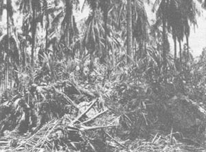
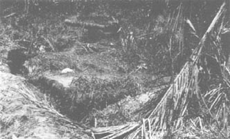
Dugouts are not feasible in the Buna area because the water table is
too close to the surface. The Japanese bunkers were, therefore, almost
entirely above ground. The base of the bunker was a shallow trench, up
to 40 feet in length for the larger bunkers, and 6 to 10 feet for the smaller.
A framework of columns and beams was set up, the walls were revetted with
coconut logs ranging up to 1½ feet in thickness, and a ceiling of
two or three courses of such logs was laid on top. Not content with this
construction, the enemy reinforced the wall, using steel oil drums and
ammunition boxes filled with sand, as well as log
14
Japanese Bunker in the Duropa Plantation.
Cpl. Charles Claridge of Reedsburg, Wisconsin, is looking at the
entrance.
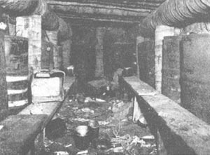
Interior of a Japanese Bunker in the Duropa Plantation.
Note the sand-filled oil drums used to reinforce the palm-log structure.
15
piles and rocks. Over all this were piled earth and sand mixed with
short logs, coconuts, and the like. When the bunker, 7 to 8 feet high,
was camouflaged with fast-growing jungle vegetation, it became almost impossible
to spot in the tangled underbrush. The campaign was to prove that as a
shelter it would withstand almost anything but a direct hit by a heavy
artillery shell with delayed-action fuze. Entrances to the bunkers usually
were in the rear, covered by fire from adjacent bunkers, and often angled
so that a hand grenade tossed in the door would not kill the occupants.
Some of the bunkers had fire slits for machine guns or rifles. In this
case snipers in the trees overhead served as observers. The snipers would
fire warning shots when our troops approached, and then a machine-gun burst
would come from the bunker. The bunkers, however, were principally used
for shelter during aerial bombardment and shelling. After such attacks
the Japanese crawled out along the communication trenches and took up firing
positions in individual emplacements to the sides and front of the bunkers.
Not all of these shelters were occupied at any one time; the garrison shifted
from point to point to meet our attack, and our troops soon learned that
each captured bunker must be garrisoned or destroyed to prevent the enemy
from infiltrating and reoccupying it. The Japanese worked steadily to improve
and strengthen their system of defenses and constructed new lines as they
were forced back.
Japanese tactics during the Buna campaign were strictly defensive. Counterattacks
were few and came mostly at the end of the operation, when the enemy's
situation was growing desperate. For the most part he dug himself in and
waited for our troops to cross his final protective lines. Time and time
again our troops were baffled by the enfilading fire from positions they
could not see. As the soldiers kept complaining, "If we could only see
them, it wouldn't take long." But the Japanese light machine guns and Arisaka
rifles gave off no flash, and in the great tent of towering trees sound
so reverberated that the report of a weapon did not aid in its location.
Our troops had to locate each bunker by costly fumbling, then either outflank
it by creeping through a swamp or charge it again and again until the defenders
were worn out. The Japanese never surrendered. As one soldier explained,
"They are tough babies all right, but I guess part of the toughness comes
from them not being able to go any place else; they just stay there and
die."
16
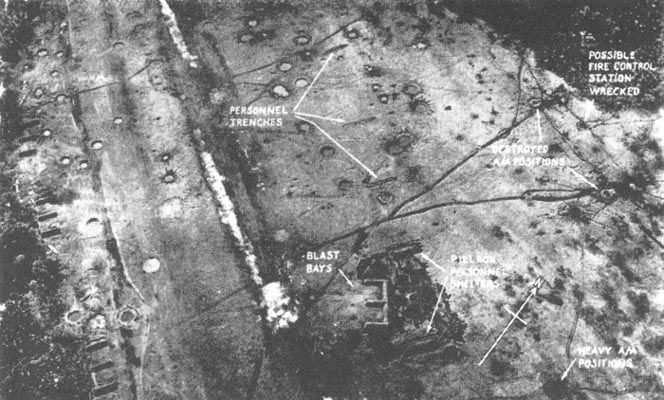
The Old Strip, Buna, Showing Japanese Fortifications.
Firing Pits and Bunker Entrances, Buna Mission.
17
AIR-GROUND COOPERATION
Our victory at Buna was the, fruit of cooperation between ground and
air forces. Either without the other would have failed. The Australian
and American units of the U. S. 5th Air Force, under Lt. Gen. George C.
Kenney, met all demands, strategic, tactical, and logistic. Though our
squadrons were often outnumbered and always short of pilots, planes, and
supplies, they were stronger than the forces which the Japanese could spare
from their major effort in the Solomons. The skill and courage of Allied
fliers, in combination with the superiority of our planes, won aerial mastery
over the southeastern end of New Guinea. Our control of the air made large-scale
reinforcement of the enemy troops in the area cost more than the Japanese
were willing or able to pay in terms of losses. At the same time, we were
able to bring in the soldiers and supplies to drive the enemy from Buna
and Sanananda.
Our control of the air was won by constant patrolling, armed reconnaissance,
and aggressive fighter operations.4 Yet we could not monopolize
the air and considerable numbers of hostile planes from time to time succeeded
in breaking through to bomb and strafe our troops and rear areas. For example,
on 7 December, 3 Japanese navy dive bombers and 18 Zero-escorted high-level
bombers attacked the 2d Field Hospital at Simemi, causing heavy casualties.
As late as 27 December, when the enemy was withdrawing toward the sea for
his last stand, 41 Zeros and dive bombers attempted to raid our positions
but were intercepted by 8 of our P-38's. Two enemy planes were shot down,
and the 3 bombs dropped did no damage. However, the
4. Tabulation of cooperation by the 5th Air Force in the New
Guinea area, 1 November 1942-23 January 1943:
NUMBER OF MISSIONS ASSIGNED
| Type of plane |
Aerial reconnaissance and observation |
Armed reconnais-sance, escort, and patrol |
Attack on enemy aircraft |
Bombing and strafing |
Total |
| Heavy Bomber |
|
116 |
1 |
47 |
164 |
| Medium Bomber |
|
45 |
|
88 |
133 |
| Light Bomber |
|
28 |
|
74 |
102 |
| Fighter |
35 |
38 |
3 |
63 |
139 |
| Miscellaneous |
|
73 |
|
|
73 |
| TOTAL |
35 |
300 |
4 |
272 |
611 |
18
enemy could not maintain a continuous or effective aerial offensive
and suffered severe losses in his occasional raids. He never completely
severed our fragile lines of communication.
Strategic bombing and strafing of enemy airfields at Lae, Salamaua,
and Rabaul by the 5th Air Force was severely limited by the small number
of planes available. Between 1 November 1942 and 31 January 1943, only
13½ tons of explosives were dropped on ground targets and shipping
outside the coastal region of southeastern New Guinea. At the same time,
however, the 13th Air Force was engaging large numbers of Japanese planes
in the Solomons and was also bombing Rabaul. These attacks had an effect
out of proportion to their apparent weight, for they compelled the enemy
to allocate part of his strength to defense of his bases and restricted
his ability to interfere with Allied operations in the Buna-Sanananda area.
Tactical bombing and strafing of enemy forward areas played a relatively
small part, for such operations early proved almost as dangerous to our
own troops as to the enemy. Contact between our ground units and those
of the enemy was exceedingly close and aerial observation was practically
impossible. Enemy rear areas were constantly pounded by our B-25's and
A-20'S, yet during the 6 weeks of active operations only 163 tons of bombs
were dropped and 144,790 rounds of ammunition fired on the Buna Mission
and Old Strip area. Bombardiers in the combat zone usually had to aim at
jungle-covered ground targets visible only at extremely low altitudes.
In most instances, pilots had to report "results unobserved." Nevertheless,
these raids had telling effect on Japanese forward supply lines and Japanese
morale.
Tactical aerial reconnaissance and observation were likewise very difficult,
but proved invaluable to our ground forces. A flight of Australian Wirraways,
based at Dobodura late in November, gathered information contributing to
a precision in artillery fire otherwise impossible because of the inaccuracy
of available maps.
TRANSPORT, SUPPLY, AND COMMUNICATION
Of first importance and most novel was the contribution of the 5th Air
Force to the transport and supply of the ground troops. Most of our infantrymen
and supporting troops, a total of 14,900 were flown to the Buna area in
the uncomfortable bucket seats of C-47's. The
19
small amount of artillery used in the operation was all airborne for
at least part of the way. The air movement of the 128th Infantry from Australia
to New Guinea was the first large-scale airborne troop movement by United
States forces in a theater of operations. The bulk of the other units of
the Buna Force, including the 127th and 163d Infantry Regiments, were flown
by the 374th Troop Carrier Group directly to Dobodura and Popondetta, only
10 miles from the front lines. When they were wounded or when they fell
ill of tropical diseases, the troops left as they had come; the planes
which brought in reinforcements and supplies returned to Port Moresby laden
with hospital cases, many of which were ferried immediately by air to Australia.
Supply of rations and equipment was an extraordinarily difficult problem
throughout the operation. Land transportation across the mountains was
almost impossible and very impractical, since there was only a rough and
steep foot trail from Port Moresby to the front and a trip over this trail
took 18 to 28 days. The distance could be flown by plane in 35 minutes.
While units near the coast relied on supply by small boats, those inland
had to depend on supply by aircraft.
The Air Force maintained a regular shuttle service across the treacherous
mountains and over the coastal jungle to deliver food for the soldiers
and native carriers, as well as the ammunition, the ¼-ton peeps
used for transport on the corduroy trails, pick mattocks, shovels, axes,
oil for the ordnance which was corroding in the steaming jungle, cots,
blankets, surgical instruments, dressings, plasma, quinine and atabrine
tablets for the sick and wounded, new shoes, and clothing. The only 105-mm
howitzer used in the campaign was carried to the front by aircraft. Sixteen
C-47's and several A-29's, based at Ward's Drome, Port Moresby, delivered
a total of 2,450 tons to the landing strips at Dobodura, Popondetta, and
Pongani and dropped 166 tons at small grounds designated along the jungle
trails. Small arms, ammunition, mortar shells, and medical supplies were
dropped with parachutes; food, clothing, and individual equipment other
than arms, without parachutes.
The losses in dropping without parachutes averaged 50 per cent. For
example, cans of bully beef broke open and spoiled. Dropping grounds were
hard to find; smudge fires and panels often did not
20
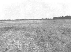
Strip No. 4 at Dobodura.
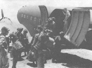
American Troops Embarking in a C-47.
21
identify the area sufficiently, and occasionally loads landed in enemy
territory. Hungry men watched every incoming plane for good drops. "Convey
our compliments to pilot and crew of Dutch Boy. They really laid
delivery on the door step," said Maj. Herbert M. Smith, speaking for the
2d Battalion, 126th Infantry.
Pilots made their turn-around as quickly as possible. Two planes, Sleepy
Sally and Eager Beaver, on 4 December made two trips from Port
Moresby to Hariko, a distance of 90 miles, and dropped both loads at Hariko
within 2 hours and 15 minutes.
Approximately half of the supplies were seaborne. On 14 November, 45
tons a week of rations for the men on the east flank were ordered shipped
to Pongani via Milne Bay. Cargoes were transferred at Milne Bay from ocean
freighters to smaller vessels of 50 to 500 tons, which crept around East
Cape and through Ward Hunt Strait to Oro Bay. Enemy planes and surface
craft made it dangerous for ships to remain at Oro Bay during daylight
hours, so loads were transferred to smaller craft which made hazardous
nightly runs through reef-studded coastal waters to an advance supply base.
There the troops, partly infantry, partly units of the 107th Quartermaster
Battalion, put out through the surf in native outrigger canoes and unloaded
the cases of food and equipment.
This seaborne supply line remained always under threat of interruption.
Attacks by enemy planes on 16-17 November put it out of operation for 3
weeks. The 22d Portable Hospital on the Alacrity, one of the four boats
sunk in the first of these attacks, lost four men and all of its equipment
and supplies. On 23 December, two enemy PT-type boats sank a ship off Hariko
and machine-gunned the supply base. However, through most of the period,
the Allied forces on the east flank were successfully supplied by the sea
route.
The chain of supply stretched 4700 miles from bases in Australia to
the landing fields, dropping grounds, and coastal dumps. From such forward
points, cargoes had to be transported to the men in and directly behind
the combat lines. This last vital transport link was formed by a few peeps
and some 700 fuzzy-headed native carriers, who delivered their 40 pounds
apiece to dumps just outside the range of small-arms fire.
Requests for supplies flowed from the front to Lt. Col. Ralph T. Birkeness,
Division Quartermaster at Port Moresby. All were marked
22
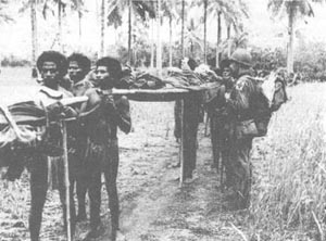
Native Stretcher Bearers with Wounded American.
On the trail from the Buna Front to Simemi.
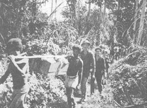
Supplies for Headquarters.
Native carriers and guards on the trail from Oro Bay to the Buna
Front.
23
urgent. He had to assign priorities on the limited space of the planes
and boats, determining whether the soldiers would receive bullets or rations,
or food for the natives who were indispensable as carriers and would go
home unless fed, or replacements for the ordnance watches "going to hell"
in the damp climate of the Papuan jungle and needed for synchronization
of combat efforts, or canister and flame throwers when weapons available
in the front lines failed to solve tactical problems. On one occasion,
General Harding wired from his advanced headquarters, "So many priorities
on medical, engineer, antiaircraft and other [supplies] are causing neglect
of general ammunition and food for our fighting men."
Quartermaster officers in the field reported that the troops subsisted
for almost a week on a daily diet of one-third of a "C" ration and one-sixth
of a "D" ration,5 equivalent to about 1,000 calories a day.
Even when shipping space was available, the problem was not solved. Foods
in glass jars were packed in paper cartons which disintegrated in the rain.
The jars, unprotected by cartons, often broke. There was a shortage of
packing equipment. Parachutes used for the drops had to be salvaged for
further use. However, as the operation progressed, both headquarters and
officers at the front learned by trial and error what was needed, in what
quantity, and how to use efficiently the available transportation.
The establishment and maintenance of communications across the Owen
Stanley Mountains and in the Buna area involved many difficulties. Shortage
of space on the air supply line from Port Moresby limited delivery of equipment.
Radio sets corroded or shortcircuited in the hot, moist air even when protected
from the heavy rains. The more powerful radios used for communication between
the front and Port Moresby worked well, but the limited Signal Corps staff
was swamped with the coding and decoding of messages. Portable radios were
often ineffective because the dense growth of trees and underbrush limited
their range.
Headquarters at Simemi was connected with Dobodura, Hariko, and Oro
Bay by teletype. Telephone wires were laid to each regimental headquarters,
to the four air strips, to aircraft warning stations, and to all artillery
batteries. Where jungle and swamp were absolutely impenetrable, reels were
mounted on rafts and field wire was
5. A "C" ration weighs 4.2 pounds and a "D" ration consists
of three chocolate bars.
24
strung on trees as the rafts floated downstream. Altogether some 300
miles of wire were laid, all of it by hand and much of it under fire. On
23 December, 1st Lt. Philip S. Winson of the 32d Signal Company, while
laying a battalion observation post telephonc line, was with a platoon
of the 126th Infantry which was isolated by enemy counterattack. For organizing
the defense of several captured enemy bunkers, he received a citation.
Lines were frequently broken by enemy patrols or bombing. Native carriers
innocently cut lengths of wire to tie up their bundles. Repair parties
were sniped at by the Japanese in daylight, and at night were fired on
by our own men, who were suspicious of any movement in the dark. However,
communications were maintained effectively throughout the operation; few
complaints were heard.
25
page created 10 July 2001
Return to the Table
of Contents
Return to CMH
Online