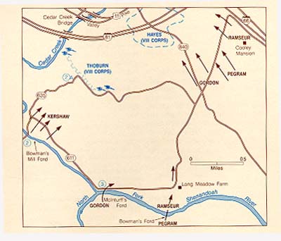
This is McInturff's Ford where Gordon's Division crossed the river. Ramseur's Division crossed at Bowman's Ford, .6 mile farther east, followed by Pegram's Division. The night was chilly, and many Southern soldiers complained of their muscles tightening in the cool night air whenever they paused to rest or to close up the lines. The entire approach could have been bungled were it not for General Gordon's attention to detail. The trail had been blazed and improved as much as possible by Early's engineers. Guides were positioned at most junctions except at one place where a log was placed to block a fork in the trail. As luck would have it, a local farmer had innocently moved the log. Gordon sensed that night that the log had been moved; he halted the column, verified the change with the nearby farmer, and got the troops on the right path. Thus, the man who conceived the grand strategy of the attack had assured its initial success by his equally sure attention to detail.
Continue on CR 611 (eastward); in .6 mile you will pass Long Meadow Farm on the right.
Bowman's Ford is just to the south of the farm, where the tree line reaches the river. CR 611 turns north at this point, following the approach route of Gordon's corps.
Proceeding .8 mile farther, where CR 635 takes off to the left, you are about 800 feet east of Gordon's southern flank as it faced west-northwest to go into the attack. The northern flank, Ramseur's Division, was .9 mile farther up 611 where it changes direction because of I-66. Gordon saw the Greek-revival Cooley House when he was making his plans from atop Massanutten Mountain. He knew that when the head of the column reached the house it had only to halt and face left (west) to be in position.
Turn left (west) onto CR 840 at the stop sign .1 mile beyond the 635 junction.
Buckton Ford is 2.1 miles to the right (eastward) down this road. That was where the bulk of Colonel Alpheus S. Moore's U.S. Cavalry Brigade was stationed. Going westward, you are following Gordon's axis of advance. In about half a mile, the road drops into a small stream valley. As you reach the bottom, a power company cut to your left front reveals a ridge 300 yards away. Hayes' Second Division, VIII Corps was preparing trenches along this line. They were unoccupied at the time of attack except for some men from the Fifth New York Heavy Artillery Regiment who were digging them. The road then rises and goes under I-81. At this point the Interstate traces the center line of Hayes' Second Division, VIII Corps. The hillside on both sides of the Interstate saw heavy fighting between about 0530 and 0600. As recalled by John B. Gordon,