Invasion Planning
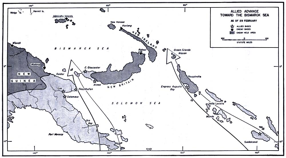
GENERAL DOUGLAS MACARTHUR, Commander-in-Chief of the Southwest Pacific Area, referred to the conquest of the Admiralty Islands as "putting the cork in the bottle." Inside the bottle was a major segment of the outer defenses for Japan's Pacific Empire, a segment which barred Allied advance from the Southwest Pacific toward the Philippines and which protected the flank of Japanese strongholds on the north coast of New Guinea (Map No. 1 opposite). The enemy bases on the islands of the Bismarck and Solomon Seas formed an integrated defensive system. Sea and air power linked the scattered garrisons and furnished the striking forces to meet Allied invasion; many harbors were available for shipping, and a network of airfields permitted quick transfer of planes for support of any threatened point. The capture of the Admiralties was one of the last steps in the campaign which sealed off the Bismarck-Solomons area from supply and reinforcement, denied its use to the enemy for effective air and naval operations, and left garrisons totaling over 100,000 troops in isolated impotence.
The offensive that produced these results had begun in the summer of 1943, from bases in New Guinea and Guadalcanal which represented the Allies' first, hard-won conquests (Map No. 2 page 2). The attack was delivered along two widely separated axes of advance. Under direct command of General MacArthur, Australian and United States troops struck northwest along the coast of New Guinea. From Guadalcanal, Admiral William F. Halsey's forces of the South Pacific Command took a parallel route through islands of the Solomons chain, with objectives and a time schedule set
1
MAP NO. 2 Allied Advance Toward the Bismarck Sea, as of 29 February
[2]
by General MacArthur. Naval and air forces were of major importance in the offensive: the navy to transport invading forces, protect their advance and supply lines from sea attack, and help reduce enemy coastal defenses; the air force to cover the amphibious attacks, neutralize enemy air power, and cooperate in the ground operations.
The strategy of the Allies showed full appreciation of the decisive importance of air power in the island area. Each offensive move had the primary aim of securing air bases, from which a whole new set of enemy strongholds could be reached, cut off from supply by sea, made useless for enemy air operations, and then bypassed. Once firmly established, a forward air base could effectively hold off enemy naval intervention and cover the next bound in the offensive. By this technique, ground assault on main enemy fortifications was reduced to a minimum. The Japanese were unable to hold in force all the extensive coastline of the island archipelagoes, and so the Allies could often pick relatively undefended objectives with terrain suitable for development of airfields. Mounting each amphibious blow with concentrated naval and air strength to protect it, they seized a series of bases from which to dominate the air and sea within fighter range. One after another, Japanese garrisons were left behind our advance. Lacking the means to undertake offensive action by air and sea, bypassed garrisons on isolated islands presented no threat to Allied lines of communication. On other larger islands, these garrisons might undertake land operations against Allied beachheads, but once the Japanese were cut off from supply and reinforcement their striking power would steadily diminish.
The central Japanese base, key to enemy defense of the Bismarck-Solomons region, was the great harbor of Rabaul in the northeast corner of New Britain Island. To it came supplies from the west either by way of staging points along the New Guinea coast, or through Ninigo and the Hermit and Admiralty Islands; another main enemy line of supply came down from the great staging base at Truk some 800 miles to the north in the center of the Carolines. Rabaul was protected by its own airfields, which could easily reinforce the many air bases on enemy-held islands to the south and east. Conquest of Rabaul, or of bases from which to cut its communications, was a main objective in the Allied campaign.
By February 1944, major progress had been made toward this objective. On New Guinea, General MacArthur's forces had
3
reached Salamaua and Lae in September 1943, Finschhafen in October. From these bases, which permitted air and sea control of the southern entrance to the Bismarck Sea, General MacArthur struck north at New Britain in December, seizing Arawe and Cape Gloucester. These conquests opened a water entrance to the Bismarck Sea, and put units of the Fifth Air Force, commanded by Lt. Gen. George C. Kenney, less than 300 miles from Rabaul. Early in January Saidor, on the New Guinea coast, was taken.
Admiral Halsey's forces had come even closer to Rabaul. Their island-hopping progress started with Munda and Vella Lavella in August; then, in November, came the bold landing on Bougainville Island, a major experiment in bypassing. This netted a beachhead at Empress Augusta Bay with a base for bombers and fighters 220 miles from Rabaul. During the next 2 months, Japanese air and shipping strength in the Rabaul area was worn down by constant air attacks. On 15 February, Nissan Island was occupied by American forces against negligible opposition, putting Halsey's advance only 125 miles east of Rabaul and within good striking range of its approaches from the north. Meanwhile, enemy reinforcement from this direction was rendered less likely by the U. S. naval offensive in the Central Pacific, in particular the raid upon Truk on 16 February which destroyed 201 planes and 23 ships.
This was the background for final moves to neutralize the Bismarck-Solomons area. One of the decisive strokes, planned since November 1943, was the attack on the Admiralty Islands.
The Objective
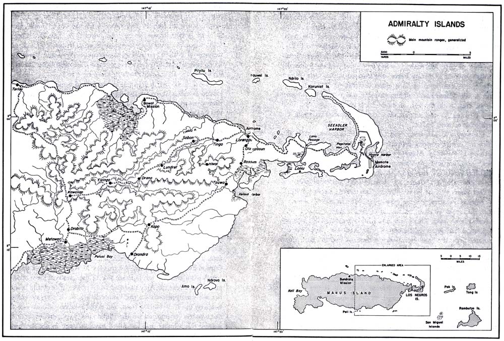
The Admiralties lie some 200 miles north and east of New Guinea and 260 miles west of the tip of New Ireland. Manus is by far the largest of the two main islands (Map No. 3, pages 8-9). Separated from Manus by a shallow, creek-like strait, Los Negros, the next largest island, extends in a rough horseshoe curve to form a natural breakwater for Seeadler Harbor, the most extensive of several anchorages. A series of smaller islands, running parallel to the northern coast line of Manus, outpost the harbor. Its principal entrance is a passage between Hauwei and Ndrilo Islands, shown on charts as a free channel, 1½ miles wide and 100 feet deep. The surveyed portion of the harbor itself was 6 miles wide and more than
4
20 miles long. Depths ranged up to 120 feet. From a military standpoint, Seeadler Harbor, the settlement of Lorengau with its auxiliary landing field, and the central part of Los Negros, site of the large Momote airfield, were the most important areas on the islands.
The Admiralties were discovered in 1616 by Dutch voyagers, but no nation had claimed them until 1885 when Germany extended its rule to the entire Bismarck Archipelago. In 1914 Australian military forces occupied the island group, and after the first World War the area was allotted to Australia as a League of Nations Mandated Territory. In 1940 there were about 13,450 natives on the islands,
5
most of whom lived on the eastern part of Manus and on Los Negros. Coconut was the only commercial crop produced there, but yams, taro, sweet potatoes, and bananas flourished in the native gardens. The tall, strong, dark brown natives, Melanesians with some Micronesian blood, dived for trochus and pearl shell in nearby waters and used the pearls and shells for barter. They built large outrigger canoes, having as many as four square sails, which were swift and could sail well into the wind.
Los Negros Island is broken by fingers of the sea, which form many harbors and lagoons. Papitalai Harbor, connecting with Seeadler on the western side, and Hyane Harbor, the largest eastern inlet, almost join to cut the island in half. A low, sandy spit only 50 yards across separates these bodies of water. This land obstruction had been overcome by the natives who built a skidway across it over which to drag their canoes. From the skidway, north around the head of Luaseu Creek and up the northern prong of Los Negros, the Japanese had laid down a 10-foot road of coranus, a decomposed coral which forms a hard surface. Here the land is mostly plantation or swamp. Below the skidway the Momote area, in the center of the island, is generally flat, well-drained, and fertile. Farther west, near the passage dividing Los Negros from Manus, 3 groups of hills covered with dense rain forests and jungle growth reach elevations of about 200 feet. In the southwestern section densely covered hills would hamper the movement of troops.
On Manus Island an attacking force would face the prospect of fighting into country much of which had been unexplored by white men before 1927. Large stretches of the coast were uncharted or known to be choked with reefs. For the most part, the island is covered by rain forest with a thick mangrove growth at the shore. A mountain range, running the entire length of Manus, reaches heights in the southeast of 2,000 to 3,000 feet. A network of streams, navigable for several miles inland and fordable except in times of flood, served the natives as principal routes of transportation. The main land routes were four tracks leading from Lorengau to native settlements. Three of these crossed the uplands and ended in the interior; the longest ran around the north coast from Lorengau to the western end of the island.
At 2º south latitude, the weather on these islands is hot and the humidity high; annual rainfall is 154 inches. The rainiest months are
6
usually July and August, but throughout the year the sky is cloudy about half the time. Thunderstorms, especially frequent in inland regions, are common everywhere on the islands. There is no cool season, but from May to November, when the wind usually blows from the southeast, temperatures are lower than from December to May, when the northwest monsoon prevails. In the Bismarck area transitional periods between seasons occur in April and November. At these times, landing forces might expect the calm water favorable for operations on exposed coasts or submerged reefs.
On 7 April 1942 a Japanese destroyer and a merchant ship had landed invading forces at Lorengau, driving off the hundred or so Europeans who had been living there. At that time the only air strip was at Lorengau, the administrative center for the group of islands. Apparently the Admiralties were not considered significant in the offensive phase of the Japanese conquest of the South Pacific area, for it was not until February 1943, that construction forces started to build a 5,000-foot air strip at Momote Plantation on Los Negros and to put the 3,000-foot Lorengau airfield into operational use. After October 1943, the Momote field and the smaller Lorengau strip served as ferrying stops on the replacement routes to Wewak, Hollandia (200 miles northwest of Wewak on the New Guinea coast), and Rabaul, until Allied air attacks destroyed the effectiveness of the Admiralties' base. Seeadler Harbor was also being used for surface craft and possibly for seaplanes.
Capture of the Admiralties would represent a strategic gain of the greatest importance. Three hundred and sixty miles west of Rabaul and two hundred miles from the Wewak-Madang coastal area, the islands were not only near the center of the great semicircle formed by the main enemy defenses on New Guinea and the Bismarcks, but were on the Japanese side of this crescent. Developed as an offensive base for Allied air and naval power, they would control the western approaches to the Bismarck Sea, flank Japanese strongholds on the New Guinea coast, and protect Allied advance into the open waters leading toward the Philippines. Furthermore, both for staging this advance and for Allied naval strategy in the Southwest Pacific, Seeadler Harbor would be a major prize. Its sheltered anchorage had ample room, including the dispersal area necessary in defense against air attacks, for the largest fleets of capital ships and escorts.
7
[8-9]
The Attack Date is Advanced
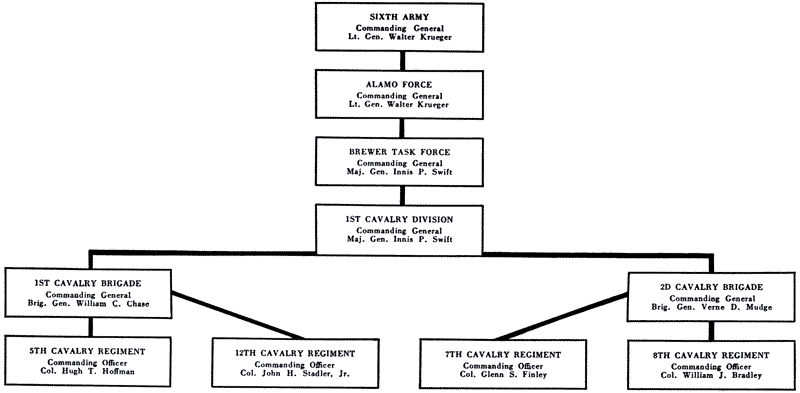
The general plan of the offensive to be carried out by Southwest Pacific and South Pacific forces had been outlined by May 1943. At this time General Headquarters, Southwest Pacific Area, designated the various operations required for the ultimate reduction of Rabaul and the Bismarck Archipelago. On 23 November 1943 further instructions from General MacArthur's headquarters assigned the Admiralty Islands operation to Alamo Force, commanded by Lt. Gen. Walter Krueger and composed of units either assigned or attached to the Sixth Army. Alamo Force's definite mission was to seize the Seeadler Harbor area, with the aim of establishing an airdrome and light naval facilities for the support of subsequent operations along the north coast of New Guinea.
Planning was well under way when General Headquarters amplified the earlier warning instructions in an order issued to Alamo Force on 13 February. Alamo Force was to seize all of the Admiralties,1 complete and maintain the light naval facilities previously called for, and in addition begin work on a major naval base. These instructions named Momote and Lorengau as airdrome sites and Seeadler Harbor as the invasion zone. The target date was 1 April.
During February enemy capabilities for air action, always a major factor to consider in planning amphibious assaults, were evaluated downward. There were many indications that the Japanese air position had greatly deteriorated throughout the New Guinea-Bismarck area; the bombing of enemy air bases and the destruction of his planes was paying off. An intelligence report for February stated that enemy airdromes throughout the Bismarcks were generally inoperative, although there was no assurance that some of the strips would not be put back into use. By this time Japanese planes rarely took to the air except in defense of Rabaul. It was reported that in a week Japanese air strength in the Bismarcks had dropped from 536 to 322 planes and that "it is probable the estimate is not keeping pace with developments." An intelligence report of 27 February spoke in terms of a strategic air withdrawal from the area.
On the New Guinea side of the Admiralties, the enemy base at Wewak remained a threat to movement into the Bismarck Sea, and
1. This plan also outlined a simultaneous attack, later cancelled, on Kavieng.
10
toward the end of February the air strength there was estimated at 200 planes, including more than 80 fighters. However, these had not tried to intercept the two latest raids on Wewak. The most recent threat at interception had been on 15 February, when the defending force had simply run out to sea as soon as they sighted an equal number of Allied fighters.
During 22 and 23 February five U. S. destroyers proceeded to a point about a hundred miles due east of Lorengau, sinking a 3,800-ton enemy vessel. From survivors it appeared that some 400 enemy aircraft personnel were being transferred to bases farther north at Palau and Truk. Three of the destroyers then went south of New Hanover where they sank an enemy destroyer and a cargo ship; from there they skirted the coast of New Ireland and passed through the channel opposite Rabaul between New Ireland and New Britain, before they returned to their base. The other group went north of New Hanover and bombarded the enemy base at Kavieng; enemy shore batteries guarding this base returned fire without effect. At no time was there evidence of air opposition, although the destroyers' course was through waters that Japanese planes had been accustomed to patrol from their bases in New Ireland and in the Admiralties. The destroyers' sweep was also evidence of the disappearance of hostile naval units from waters that they once controlled. An intelligence estimate at the end of February put enemy sea strength in the large area between the Bismarcks and East Borneo at 9 destroyers, 16 submarines, and miscellaneous patrol craft.
The situation was such that enemy defense of the Admiralty Islands could count on little support, air or naval, from nearby bases. In the last week of February General MacArthur changed his plans. In place of the assault scheduled for 1 April, an immediate reconnaissance in force would be made on the Admiralties, by a landing near Momote air strip on Los Negros Island. D Day was to be no later than 29 February. If the attacking troops, limited to 800 men, found the Momote area inadequately defended, they would hold on and await reinforcement; reconnaissance would then be transformed into invasion. General MacArthur believed that the island was lightly held and that there was opportunity for a "coup de main" by a surprise landing. He himself would accompany the reconnaissance operation, in order to judge how far the enterprise
11
should be pushed. If it succeeded, the landing force would prepare the Momote air strip for transport planes, and engineers would arrive at the earliest possible moment to prepare the field for fighter operations.
Planning the Reconnaissance in Force
On 24 February Alamo Force Headquarters at Finschhafen received orders for the immediate reconnaissance landing on the Admiralties. By this time plans for an assault, designated as the Brewer Operation, were almost fully outlined in accordance with earlier instructions. In January General Krueger had detailed a planning staff from the 1st Cavalry Division to make a study of terrain, logistical, and other data. On 19 February, following the directive of 13 February, the first of several conferences had taken place among representatives from Alamo Force, the Fifth Air Force, and the Seventh Amphibious Force, which was under the Commander of the Allied Naval Forces of the Southwest Pacific Area, Vice Adm. Thomas C. Kinkaid. These conferences had settled all preliminary details of ground, air, and naval coordination.
The 1st Cavalry Division had been designated as the nucleus of the task force assigned to this operation. Mal. Gen. Innis P. Swift, commanding the division, and his staff were at Finschhafen and had been included in the conferences at Alamo Force Headquarters. The division itself was already at Camp Borio in the vicinity of Oro Bay, staging area for the Brewer Operation, and was training intensively for its first combat duty in this war.
Although the 1st Cavalry Division was dismounted for operations in the Pacific, it retained its organization as a cavalry unit with two brigades, each made up of two reinforced regiments. In addition to supporting units, each regiment comprised two squadrons of three rifle troops and a heavy weapons troop. Regiments of this division, the 5th and 12th of the 1st Brigade, and the 7th and 8th of the 2d Brigade, are proud of their share in the military exploits of the United States. The 12th Cavalry, newest of the four, was organized in 1901. The 5th Cavalry, the oldest, was organized in 1855 by Jefferson Davis, then Secretary of War; among its commanders were Robert E. Lee and Jeb Stuart. Eighteen battle streamers on the 5th Cavalry's regimental standard represent actions in the Civil War,
12
Chart: ORGANIZATION OF UNITS IN THE ADMIRALTIES CAMPAIGN
13
at Big Horn and on the Yellowstone, and in the Villa expedition into Mexico. The 7th and 8th Cavalry Regiments, dating their organization from 1866, also took part in the Indian wars, in which one squadron of the 7th Cavalry, under Custer, was wiped out at the battle of Little Big Horn in 1876. Both regiments served in the Philippines before the first World War. In 1940 and 1941 the 1st Cavalry Division participated in the Louisiana maneuvers and in 1943 shipped to Australia, where the men had 5 months' training for jungle and amphibious operations. During December and January they had begun the move to Oro Bay for further training before the assault on the Admiralties. On 26 February Brewer Task Force was
MAP NO. 4 Plans for Initial Landing, 29 February
14
officially constituted, with the 1st Cavalry Division's commander, General Swift, in command.
The new orders did not alter the final mission of the Brewer Task Force, to establish the Admiralties as an advance air and naval base for offensive action. Main changes were in the landing place and the timing of the move. The attack was now to be aimed at the eastern coast of Los Negros instead of at the Seeadler Harbor area to the northwest, and Momote airfield was to be the initial objective if the force remained to occupy the island. Since D Day was to be before the end of February, the time limitation was severe. At the most, only 5 days were left for final planning and preparation, including the movement of troops from a staging area 500 miles south of the Admiralties.
General Krueger's headquarters set 29 February as D Day and at once began making the necessary revision of operational plans. Air and naval participation was radically affected by the changed schedule. Under the old plan, the air force was to begin a month before D Day carrying out continuous air strikes to neutralize enemy bases on northern New Ireland and the Admiralties. Further tasks were to maintain a blockade of the Kavieng-Manus area and to keep Japanese air strength beaten down throughout the Bismarcks and along the New Guinea coast. The Navy, prior to D Day, was to employ diversionary bombardment against selected points on southern New Britain. Naval forces were also to conduct minesweeping missions and make hydrographic surveys of harbors and approaches in preparation for the landing. The change in timing entailed the discarding of many of these preliminary moves. Instead of having a month before the landing in which to extend even further its efforts to knock out enemy bases, the air force would concentrate on bombing the objective area and northern New Ireland. The Navy gave up the bombardments against New Britain. It would transport troops and supplies, protect their overwater movement, and furnish a heavy bombardment to cover the approach and initial debarkation. Plans for naval fire support were kept flexible until reconnaissance - could reveal more about the new target area.
Plans for ground reconnaissance prior to the landing had also to be changed. Reconnaissance was to have been made by a party which would go ashore on the western end of Manus Island from a submarine, remain on the island for a few weeks, and work east-
15
ward, maintaining radio contact with Alamo Force Headquarters. just as the men were ready to embark on this mission they were called back. Since the initial objectives were now on the eastern side of Los Negros, where Hyane Harbor offered the only known landing beach, reconnaissance efforts would be directed toward that area.
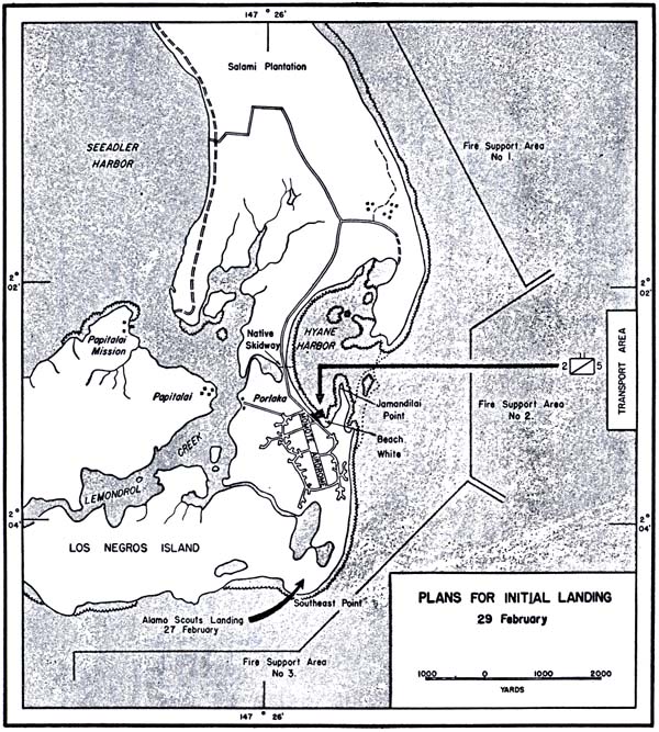
Earlier intelligence as well as recent aerial studies showed the advantages and drawbacks of Hyane Harbor as the attack area. At the harbor entrance, two flanking points of land only 1,700 yards apart might enable the enemy to lay down effective cross-fire against our landing craft as they maneuvered through the 50-foot break in the reef which encircles the island (Map No. 4, page 14). Within the harbor, boats would have to head for the south and southwest part of the bay, since the north and northwest shores were swampy.
16
The beach at the south was not more than 1,200 yards long and was composed of firm sand and shingle, passable to motor transportation. Beyond the beach only the jetty area was cleared. Elsewhere the ground was covered with secondary growth and the trunks of fallen coconut trees. The shortest route to the Momote airdrome would be about 150 yards across this jungle terrain.
Air reconnaissance had indicated not only that the air strip was unused at this time, but that there had been no noticeable activity on Los Negros Island for the preceding two weeks. According to information gathered before 27 February from some 40 natives who had come at various times from the islands, about 2,450 Japanese were present in the Momote-Salami Plantation area; for reserves 750 in the Papitalai-Lombrurn region could be counted on, and possibly 1,100 more on Manus Island in the vicinity of Lorengau. The duty of the 2,450 supposed to be located near Momote would be primarily that of guarding the airdrome; therefore field fortifications might be expected. In particular, dual-purpose 25-mm pompoms were reported to be organized in depth in a perimeter around the airdrome.
Although further confirmation of estimated enemy strength and dispositions in the vicinity of Momote would have been helpful, it was too late to send a scouting party to the beach inside Hyane Harbor, since this might tip off the enemy. All that could be done to supplement other intelligence was to order a patrol on 27-28 February of areas a mile south of the harbor. The ground party was made up of Alamo Scouts, a volunteer organization which was part of the Sixth Army. These men had been trained to live off the land for weeks at a time, to avoid contacts with the Japanese, and to make use of natives familiar with the topography of the islands and the disposition of Japanese troops. Under cover of a bombing attack the scouts landed at dawn on the southeast coast from a Catalina flying boat. Apparently the enemy was still present in force; the Alamo Scouts discovered a large bivouac area on the southeast part of Los Negros and reported that the region between the Momote air strip and the south coast was "lousy with Japs."
This information permitted more specific bombardment plans, and on the afternoon of 28 February operations orders were completed for Naval Task Force 76, commanded by Rear Admiral Daniel E. Barbey. Three fire support areas had been established for
17
the attack group, consisting of nine destroyers and the three destroyer-transports which were carrying the reconnaissance force. These areas covered the entire seaward side of Los Negros from the south coast to the northern end of Salami Plantation. In the final plans the attack group would bring the weight of its fire power against targets around Hyane Harbor and to the north. Additional fire to cover the southern part of the island would be furnished by another task group of two cruisers and four destroyers, which would meet the convoy at Cape Cretin. It was decided to split this latter group, giving one cruiser and two destroyers responsibility for the Japanese bivouac area, southwest of the Momote strip, which the Alamo Scouts had located. The other cruiser and two destroyers would fire on targets in the Lorengau-Seeadler Harbor region. In the 15-minute bombardment, scheduled from H-35 to H-20, 5-inch naval guns were each to expend approximately 350 rounds.
Under the air force plan, two groups of heavy bombers would attack ground targets on Los Negros from H-28 to H-20. Two minutes later, four groups of medium bombers were to bomb and strafe the landing area until the first wave was ashore. Following H Hour a squadron of medium bombers and six smoke planes were to be on air alert for further missions.
The 1st Cavalry Division provided units for the assault force. In the orders that came down on 24 February, General Headquarters had recommended that a cavalry squadron should make the initial reconnaissance landing, reinforced by one airborne antiaircraft battery, one light field artillery battalion, a pioneer detachment, and miscellaneous troops, numbering in all some 800 men. The final orders from Brewer Task Force followed the recommended selection of units, but the actual troop list comprised a force of slightly more than 1,000 men to make the first landing. This force was to be known as the Brewer Reconnaissance Force; it included the three rifle troops and the heavy weapons troop of the 2d Squadron, 5th Cavalry: 800 men with their complement of light and heavy machine guns, rocket launchers, and mortars. With them was a platoon from Battery B, 99th Field Artillery Battalion, carrying two 75-mm pack howitzers, four .50-caliber machine guns, and small arms. The 673d Antiaircraft Machine Gun Battery, a unit of some 80 men, was equipped with twelve .50-caliber machine guns as well as individual weapons. Air and naval liaison officers and a shore fire control party
18
were scheduled to land with the attacking force; Headquarters Troop, 1st Cavalry Brigade, would furnish a reconnaissance and a communications platoon. Arrangements had also been made for a detachment from the Australian New Guinea Administration Unit, usually called ANGAU; this group was to assist chiefly in gathering intelligence, patrolling, recruiting, and dealing with the native population as their villages were liberated.
The reconnaissance force was to go in destroyers and destroyer-transports to insure a quick withdrawal if heavy enemy units approached. The ships would load only such supplies as the men could hand-carry from the landing craft. Without vehicles or animals, gun crews would have to disassemble and manhandle their own weapons. Medical troops were restricted to the organic medical unit of the 2d Squadron, 5th Cavalry, and 35 members of a portable surgical hospital. No one knew how long the men would remain ashore, but plans had been laid for supplying troops by air drop beginning on D+1, if the beachhead was held.
In the absence of detailed ground reconnaissance the plan of the landing force was necessarily simple (Map No. 4, page 15). The destroyer-transports would occupy stations in a transport area 5,000 yards off Hyane Harbor during the naval and air bombardment. The other destroyers would come to this area for unloading personnel into landing boats and then take up or resume their fire control stations. Twelve LCPR's (Landing Craft, Personnel, [Ramped]) were to carry the troops to the beach. The first 3 waves of the reconnaissance force, each comprising 4 boats, were scheduled at 5-minute intervals. Then there would be a break of 45 minutes while the boats returned to reload. Again 3 more waves would be dispatched. After another 45-minute interval, 4 more waves would follow.
The troops would go ashore at the beach, designated White Beach, near the jetties in the lee of Jamandilai Point. From there the reconnaissance force would advance and hold Momote air strip. If the undertaking proved too difficult or costly, the men would be loaded back on the destroyers in the reverse order of their landing, and the task force would return to Oro Bay.
In the event of a successful landing, the mission of the task force was to secure the Momote air strip and to prepare the field for transport and later fighter planes. Additional strength would be furnished the reconnaissance echelon on D+2 by Brewer Support
19
Force, consisting of the remainder of the 5th Cavalry and the 99th Field Artillery Battalion, as well as two batteries of antiaircraft artillery, and medical, engineer, and communications personnel. The 40th Naval Construction Battalion was to accompany this group. On order from Brig. Gen. William C. Chase, commanding general of the 1st Cavalry Brigade Combat Team, this support force, commanded by Col. Hugh Hoffman, was to leave Oro Bay for Cape Cretin, moving on a schedule which would land it at Los Negros on 2 March. The main body of Brewer Task Force, including the rest of the 1st Brigade, and the entire 2d Brigade commanded by Brig. Gen. Verne D. Mudge, was prepared to follow the reconnaissance and support forces as soon as shipping could be made available, if the operation called for reinforcement. Cape Cretin, 150 miles up the New Guinea coast in the vicinity of Finschhafen, was named as a second staging area in order to shorten the turn-around time for the transports. Detailed plans for securing and improving positions throughout the islands were suspended until the outcome of the first landing could be seen.
20
page created 28 June 2001